

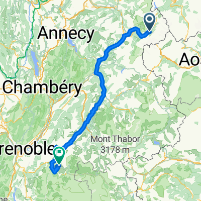
Chamonix - Col de la Ramaz (lang rute)
A cycling route starting in Chamonix, Auvergne-Rhône-Alpes, France.
Overview
About this route
- -:--
- Duration
- 101.9 km
- Distance
- 1,265 m
- Ascent
- 1,673 m
- Descent
- ---
- Avg. speed
- ---
- Max. altitude

Route quality
Waytypes & surfaces along the route
Waytypes
Road
51.6 km
(51 %)
Busy road
33.3 km
(33 %)
Surfaces
Paved
77.4 km
(76 %)
Unpaved
1.5 km
(1 %)
Asphalt
77.3 km
(76 %)
Loose gravel
1 km
(1 %)
Continue with Bikemap
Use, edit, or download this cycling route
You would like to ride Chamonix - Col de la Ramaz (lang rute) or customize it for your own trip? Here is what you can do with this Bikemap route:
Free features
- Save this route as favorite or in collections
- Copy & plan your own version of this route
- Split it into stages to create a multi-day tour
- Sync your route with Garmin or Wahoo
Premium features
Free trial for 3 days, or one-time payment. More about Bikemap Premium.
- Navigate this route on iOS & Android
- Export a GPX / KML file of this route
- Create your custom printout (try it for free)
- Download this route for offline navigation
Discover more Premium features.
Get Bikemap PremiumFrom our community
Other popular routes starting in Chamonix
 Chamonix - Val d` Isère
- Distance
- 155.4 km
- Ascent
- 3,548 m
- Descent
- 2,748 m
- Location
- Chamonix, Auvergne-Rhône-Alpes, France
 MBC to Col des Montets
- Distance
- 11.3 km
- Ascent
- 456 m
- Descent
- 37 m
- Location
- Chamonix, Auvergne-Rhône-Alpes, France
 Hurycana Blue track (col montets-vallorcine-col possettes-le tour-argentiere
- Distance
- 25.5 km
- Ascent
- 1,734 m
- Descent
- 1,743 m
- Location
- Chamonix, Auvergne-Rhône-Alpes, France
 Tour de Mont Blanc
- Distance
- 119.2 km
- Ascent
- 7,716 m
- Descent
- 7,175 m
- Location
- Chamonix, Auvergne-Rhône-Alpes, France
 Mer de Glace - Cham Sud
- Distance
- 5.9 km
- Ascent
- 36 m
- Descent
- 924 m
- Location
- Chamonix, Auvergne-Rhône-Alpes, France
 Ultimate Étapes, Stage 15: Cycling's Greatest Climb
- Distance
- 200.5 km
- Ascent
- 4,571 m
- Descent
- 3,759 m
- Location
- Chamonix, Auvergne-Rhône-Alpes, France
 Chamonix-Mont-Blanc to Lacd'Emosson
- Distance
- 32.4 km
- Ascent
- 1,622 m
- Descent
- 520 m
- Location
- Chamonix, Auvergne-Rhône-Alpes, France
 Tour Du Mont Blanc
- Distance
- 334 km
- Ascent
- 7,043 m
- Descent
- 7,041 m
- Location
- Chamonix, Auvergne-Rhône-Alpes, France
Open it in the app