

Nichien Momiji Line - Nikko 2days
A cycling route starting in Ōtawara, Tochigi, Japan.
Overview
About this route
1日目
(黒保根から桐生駅まで走行:約25km)
桐生駅から西那須野駅まで輪行
西那須野駅からキャンプ場まで走行(日塩もみじライン経由):約70km
宿泊:開運の里上栗山オートキャンプ場
温泉:開運の湯
2日目
キャンプ場から黒保根まで走行:約80km
温泉:水沼温泉センター
- -:--
- Duration
- 135.9 km
- Distance
- 2,914 m
- Ascent
- 2,853 m
- Descent
- ---
- Avg. speed
- ---
- Max. altitude
Route highlights
Points of interest along the route
Accommodation after 57 km
Kamikuriyama Campsite
Continue with Bikemap
Use, edit, or download this cycling route
You would like to ride Nichien Momiji Line - Nikko 2days or customize it for your own trip? Here is what you can do with this Bikemap route:
Free features
- Save this route as favorite or in collections
- Copy & plan your own version of this route
- Split it into stages to create a multi-day tour
- Sync your route with Garmin or Wahoo
Premium features
Free trial for 3 days, or one-time payment. More about Bikemap Premium.
- Navigate this route on iOS & Android
- Export a GPX / KML file of this route
- Create your custom printout (try it for free)
- Download this route for offline navigation
Discover more Premium features.
Get Bikemap PremiumFrom our community
Other popular routes starting in Ōtawara
 421-PC3-PC4
- Distance
- 52.7 km
- Ascent
- 344 m
- Descent
- 502 m
- Location
- Ōtawara, Tochigi, Japan
 Day 7 Nasushiobara to Yabuki Station
- Distance
- 75.2 km
- Ascent
- 1,142 m
- Descent
- 1,097 m
- Location
- Ōtawara, Tochigi, Japan
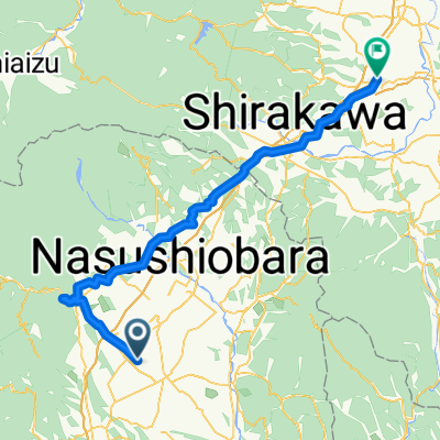
 Day 7 Nasushiobara to Shirakawa
- Distance
- 42.4 km
- Ascent
- 318 m
- Descent
- 197 m
- Location
- Ōtawara, Tochigi, Japan
 day 8 part two
- Distance
- 4.4 km
- Ascent
- 24 m
- Descent
- 12 m
- Location
- Ōtawara, Tochigi, Japan
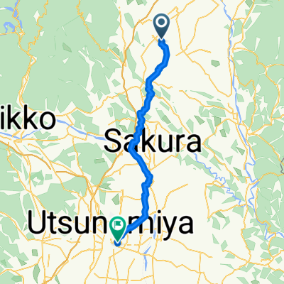 永田町, 那須塩原市へ川向町, 宇都宮市
- Distance
- 50.7 km
- Ascent
- 265 m
- Descent
- 386 m
- Location
- Ōtawara, Tochigi, Japan
 大田原市 to 3丁目, 大田原市
- Distance
- 11.6 km
- Ascent
- 57 m
- Descent
- 50 m
- Location
- Ōtawara, Tochigi, Japan
 Nichien Momiji Line - Nikko 2days
- Distance
- 135.9 km
- Ascent
- 2,914 m
- Descent
- 2,853 m
- Location
- Ōtawara, Tochigi, Japan
 20201115_おおたわら丘ポタ30 2020
- Distance
- 30.3 km
- Ascent
- 302 m
- Descent
- 304 m
- Location
- Ōtawara, Tochigi, Japan
Open it in the app