

Josh Wang Silk Road Cycling In Otto-Tokoi On12 July 2016
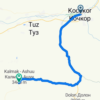
A cycling route starting in Kochkor, Naryn Region, Kyrgyzstan.
Overview
About this route
- -:--
- Duration
- 37.7 km
- Distance
- 117 m
- Ascent
- 279 m
- Descent
- ---
- Avg. speed
- ---
- Max. altitude
Route photos


Continue with Bikemap
Use, edit, or download this cycling route
You would like to ride Josh Wang Silk Road Cycling In Otto-Tokoi On12 July 2016 or customize it for your own trip? Here is what you can do with this Bikemap route:
Free features
- Save this route as favorite or in collections
- Copy & plan your own version of this route
- Sync your route with Garmin or Wahoo
Premium features
Free trial for 3 days, or one-time payment. More about Bikemap Premium.
- Navigate this route on iOS & Android
- Export a GPX / KML file of this route
- Create your custom printout (try it for free)
- Download this route for offline navigation
Discover more Premium features.
Get Bikemap PremiumFrom our community
Other popular routes starting in Kochkor
 Kochkor - Jalal-Abad
- Distance
- 453.1 km
- Ascent
- 4,722 m
- Descent
- 5,728 m
- Location
- Kochkor, Naryn Region, Kyrgyzstan
 Kyrgyz Cholpon-Ata
- Distance
- 37.1 km
- Ascent
- 128 m
- Descent
- 290 m
- Location
- Kochkor, Naryn Region, Kyrgyzstan
 KAZ_KIR_2v.14jun_6diena
- Distance
- 120.4 km
- Ascent
- 895 m
- Descent
- 1,036 m
- Location
- Kochkor, Naryn Region, Kyrgyzstan
 Kochkor - Col Song Kul
- Distance
- 72.6 km
- Ascent
- 1,387 m
- Descent
- 108 m
- Location
- Kochkor, Naryn Region, Kyrgyzstan
 Beisheev Uson street, to Пожарский көчөсү, Bishkek
- Distance
- 186 km
- Ascent
- 905 m
- Descent
- 1,913 m
- Location
- Kochkor, Naryn Region, Kyrgyzstan
 Kochkor-Torkent
- Distance
- 326.1 km
- Ascent
- 3,734 m
- Descent
- 4,616 m
- Location
- Kochkor, Naryn Region, Kyrgyzstan
 Kochkor-Km 80
- Distance
- 79.2 km
- Ascent
- 1,209 m
- Descent
- 632 m
- Location
- Kochkor, Naryn Region, Kyrgyzstan
 KAZ_KIR_14.jun_6.diena
- Distance
- 123.9 km
- Ascent
- 1,399 m
- Descent
- 1,145 m
- Location
- Kochkor, Naryn Region, Kyrgyzstan
Open it in the app