

Entlang dem Doubs und zur Ajoie
A cycling route starting in Courgenay, Canton of Jura, Switzerland.
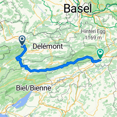
Overview
About this route
From the end point in Porrentruy, you can take the S-Bahn directly back to the starting point in Sainte-Ursanne. Alternatively, you can cycle via the Col-de-la-Croix to Saint-Ursanne (an additional 18 km and 420 m elevation gain).
- -:--
- Duration
- 42.4 km
- Distance
- 457 m
- Ascent
- 480 m
- Descent
- ---
- Avg. speed
- ---
- Max. altitude
Route quality
Waytypes & surfaces along the route
Waytypes
Road
4.7 km
(11 %)
Track
4.2 km
(10 %)
Surfaces
Paved
13.6 km
(32 %)
Unpaved
2.1 km
(5 %)
Paved (undefined)
10.2 km
(24 %)
Asphalt
3.4 km
(8 %)
Continue with Bikemap
Use, edit, or download this cycling route
You would like to ride Entlang dem Doubs und zur Ajoie or customize it for your own trip? Here is what you can do with this Bikemap route:
Free features
- Save this route as favorite or in collections
- Copy & plan your own version of this route
- Sync your route with Garmin or Wahoo
Premium features
Free trial for 3 days, or one-time payment. More about Bikemap Premium.
- Navigate this route on iOS & Android
- Export a GPX / KML file of this route
- Create your custom printout (try it for free)
- Download this route for offline navigation
Discover more Premium features.
Get Bikemap PremiumFrom our community
Other popular routes starting in Courgenay
 Entlang dem Doubs und zur Ajoie
- Distance
- 42.4 km
- Ascent
- 457 m
- Descent
- 480 m
- Location
- Courgenay, Canton of Jura, Switzerland
 2026 Fronleichnam 4. Etappe St. Ursanne- NiderbuchsitenAarau
- Distance
- 83.9 km
- Ascent
- 2,133 m
- Descent
- 2,133 m
- Location
- Courgenay, Canton of Jura, Switzerland
 Courgenay - Porrentruy
- Distance
- 55.4 km
- Ascent
- 325 m
- Descent
- 385 m
- Location
- Courgenay, Canton of Jura, Switzerland
 Col de la Croix / Lucelle
- Distance
- 47.7 km
- Ascent
- 506 m
- Descent
- 646 m
- Location
- Courgenay, Canton of Jura, Switzerland
 Col-de-la-Croix - Laufen
- Distance
- 47.2 km
- Ascent
- 545 m
- Descent
- 638 m
- Location
- Courgenay, Canton of Jura, Switzerland
 JU Porrentruy Bure St.Ursanne
- Distance
- 75.7 km
- Ascent
- 744 m
- Descent
- 741 m
- Location
- Courgenay, Canton of Jura, Switzerland
 St-Ursanne - Bordeaux
- Distance
- 1,138.8 km
- Ascent
- 1,561 m
- Descent
- 1,592 m
- Location
- Courgenay, Canton of Jura, Switzerland
 Rue de Petite-Gilberte 2, Courgenay nach Enge Gasse 10, Laufen
- Distance
- 39.8 km
- Ascent
- 310 m
- Descent
- 489 m
- Location
- Courgenay, Canton of Jura, Switzerland
Open it in the app