


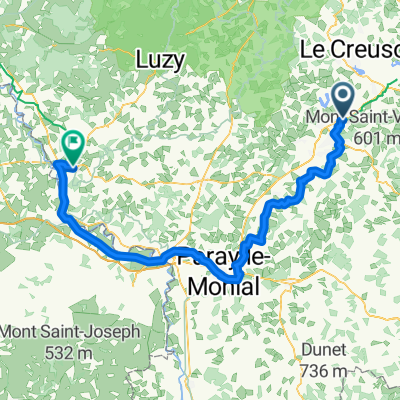
Montceau les mines 60
A cycling route starting in Blanzy, Bourgogne-Franche-Comté, France.
Overview
About this route
1
jbhjb
- -:--
- Duration
- 77.5 km
- Distance
- 281 m
- Ascent
- 307 m
- Descent
- ---
- Avg. speed
- ---
- Max. altitude
Route quality
Waytypes & surfaces along the route
Waytypes
Quiet road
25.6 km
33 %
Road
22.5 km
29 %
Surfaces
Paved
24.8 km
(32 %)
Unpaved
4.7 km
(6 %)
Asphalt
21.7 km
28 %
Paved (undefined)
3.1 km
4 %
Continue with Bikemap
Use, edit, or download this cycling route
You would like to ride Montceau les mines 60 or customize it for your own trip? Here is what you can do with this Bikemap route:
Free features
- Save this route as favorite or in collections
- Copy & plan your own version of this route
- Sync your route with Garmin or Wahoo
Premium features
Free trial for 3 days, or one-time payment. More about Bikemap Premium.
- Navigate this route on iOS & Android
- Export a GPX / KML file of this route
- Create your custom printout (try it for free)
- Download this route for offline navigation
Discover more Premium features.
Get Bikemap PremiumFrom our community
Other popular routes starting in Blanzy

 12 bis Rue Jean Monnet, Blanzy to 3 Route du Canal du Centre, Volesvres1
- 38.9 km
- 120 m
- 150 m
- Blanzy, Bourgogne-Franche-Comté, France
 1 Impasse des Petits Souliers, Blanzy to 5–11 Levée du Canal, Saint-Léger-sur-Dheune0
- 30.1 km
- 180 m
- 228 m
- Blanzy, Bourgogne-Franche-Comté, France
 37 Rue du Bois des Ranches, Blanzy to 9 Chemin de Bellecroix, Chagny0
- 80.2 km
- 1,371 m
- 1,444 m
- Blanzy, Bourgogne-Franche-Comté, France
 9 Rue Jean Monnet, Blanzy to Levée de la Jonction, Decize0
- 134.6 km
- 420 m
- 513 m
- Blanzy, Bourgogne-Franche-Comté, France

 2000–2998 Route de Montchanin, Blanzy à 25 Route de Sermoise, Sermoise-sur-Loire0
- 175.7 km
- 2,117 m
- 2,232 m
- Blanzy, Bourgogne-Franche-Comté, France


Open it in the app