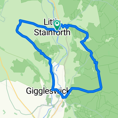
Orcaber farm, High Bentham, Ingleton, Clapham, Austwick, Orcaber farm
A cycling route starting in Settle, England, United Kingdom.
Overview
About this route
Circular trip using part of Way of the Roses route
- -:--
- Duration
- 28.4 km
- Distance
- 258 m
- Ascent
- 257 m
- Descent
- ---
- Avg. speed
- ---
- Max. altitude
Route quality
Waytypes & surfaces along the route
Waytypes
Quiet road
12.7 km
(45 %)
Road
12.7 km
(45 %)
Surfaces
Paved
7.5 km
(26 %)
Unpaved
0.4 km
(1 %)
Asphalt
7.5 km
(26 %)
Gravel
0.4 km
(1 %)
Undefined
20.5 km
(72 %)
Continue with Bikemap
Use, edit, or download this cycling route
You would like to ride Orcaber farm, High Bentham, Ingleton, Clapham, Austwick, Orcaber farm or customize it for your own trip? Here is what you can do with this Bikemap route:
Free features
- Save this route as favorite or in collections
- Copy & plan your own version of this route
- Sync your route with Garmin or Wahoo
Premium features
Free trial for 3 days, or one-time payment. More about Bikemap Premium.
- Navigate this route on iOS & Android
- Export a GPX / KML file of this route
- Create your custom printout (try it for free)
- Download this route for offline navigation
Discover more Premium features.
Get Bikemap PremiumFrom our community
Other popular routes starting in Settle
- 3 Peaks Route
- Distance
- 114.1 km
- Ascent
- 940 m
- Descent
- 940 m
- Location
- Settle, England, United Kingdom
- Hole House Lane to School Lane
- Distance
- 23.6 km
- Ascent
- 419 m
- Descent
- 383 m
- Location
- Settle, England, United Kingdom
- J-55: to England’s highest pub via Buttertubs pass
- Distance
- 46.2 km
- Ascent
- 1,072 m
- Descent
- 771 m
- Location
- Settle, England, United Kingdom
- New Way of the Rings Day 4 Settle to Ilkley
- Distance
- 59.7 km
- Ascent
- 760 m
- Descent
- 891 m
- Location
- Settle, England, United Kingdom
- 3 Peaks Route
- Distance
- 113.9 km
- Ascent
- 940 m
- Descent
- 940 m
- Location
- Settle, England, United Kingdom
- Tour de france route
- Distance
- 103.9 km
- Ascent
- 1,328 m
- Descent
- 1,328 m
- Location
- Settle, England, United Kingdom
- Yorkshire Dales - Settle to Malham Tarn loop
- Distance
- 25.6 km
- Ascent
- 531 m
- Descent
- 528 m
- Location
- Settle, England, United Kingdom
- Settle, Ribblehead, Ingleton round.
- Distance
- 47.5 km
- Ascent
- 461 m
- Descent
- 459 m
- Location
- Settle, England, United Kingdom
Open it in the app