

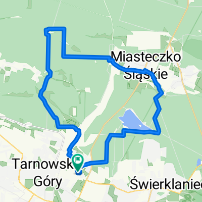
Tarnowskie Góry - Świerklaniec
A cycling route starting in Tarnowskie Góry, Silesian Voivodeship, Poland.
Overview
About this route
Tarnowskie Góry - Kalety - Zielona - Świerklaniec
- -:--
- Duration
- 61.8 km
- Distance
- 147 m
- Ascent
- 151 m
- Descent
- ---
- Avg. speed
- ---
- Max. altitude

Route quality
Waytypes & surfaces along the route
Waytypes
Track
24.7 km
(40 %)
Quiet road
17.3 km
(28 %)
Surfaces
Paved
21 km
(34 %)
Unpaved
19.8 km
(32 %)
Asphalt
19.8 km
(32 %)
Gravel
13 km
(21 %)
Continue with Bikemap
Use, edit, or download this cycling route
You would like to ride Tarnowskie Góry - Świerklaniec or customize it for your own trip? Here is what you can do with this Bikemap route:
Free features
- Save this route as favorite or in collections
- Copy & plan your own version of this route
- Sync your route with Garmin or Wahoo
Premium features
Free trial for 3 days, or one-time payment. More about Bikemap Premium.
- Navigate this route on iOS & Android
- Export a GPX / KML file of this route
- Create your custom printout (try it for free)
- Download this route for offline navigation
Discover more Premium features.
Get Bikemap PremiumFrom our community
Other popular routes starting in Tarnowskie Góry
 Świerklaniec - Ossy
- Distance
- 27.8 km
- Ascent
- 123 m
- Descent
- 127 m
- Location
- Tarnowskie Góry, Silesian Voivodeship, Poland
 Zalew Nakło-Chechło
- Distance
- 37.2 km
- Ascent
- 135 m
- Descent
- 135 m
- Location
- Tarnowskie Góry, Silesian Voivodeship, Poland
 Do dawnej kopalni rud
- Distance
- 49.9 km
- Ascent
- 3,818 m
- Descent
- 3,771 m
- Location
- Tarnowskie Góry, Silesian Voivodeship, Poland
 Tarnowskie Góry - Świerklaniec
- Distance
- 61.8 km
- Ascent
- 147 m
- Descent
- 151 m
- Location
- Tarnowskie Góry, Silesian Voivodeship, Poland
 Głęboki dół
- Distance
- 25.7 km
- Ascent
- 75 m
- Descent
- 78 m
- Location
- Tarnowskie Góry, Silesian Voivodeship, Poland
 Single Chechelskie 1
- Distance
- 5 km
- Ascent
- 17 m
- Descent
- 29 m
- Location
- Tarnowskie Góry, Silesian Voivodeship, Poland
 Bike Atelier MTB Maraton 2021 - Tarnowskie Góry - PRO
- Distance
- 76.1 km
- Ascent
- 622 m
- Descent
- 623 m
- Location
- Tarnowskie Góry, Silesian Voivodeship, Poland
 Long ride through Tarnowskie Góry
- Distance
- 82.8 km
- Ascent
- 281 m
- Descent
- 280 m
- Location
- Tarnowskie Góry, Silesian Voivodeship, Poland
Open it in the app