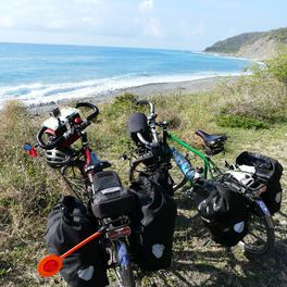
Saint Cyr - Le Cannet / sept.2013
A cycling route starting in Fontenay-le-Fleury, Île-de-France Region, France.
Overview
About this route
- -:--
- Duration
- 1,359.8 km
- Distance
- 2,324 m
- Ascent
- 2,305 m
- Descent
- ---
- Avg. speed
- ---
- Max. altitude
Route highlights
Points of interest along the route
Point of interest after 63.8 km
chez Jipé et Caroline WS
Point of interest after 109.5 km
camping municipal
Point of interest after 181.3 km
camping
Point of interest after 225.6 km
camping
Point of interest after 278.2 km
camping municipal
Point of interest after 355.8 km
camping curistes
Point of interest after 391 km
camping la chevrette
Point of interest after 432.8 km
CH la Musardière
Point of interest after 478.9 km
camping de Mars
Point of interest after 529.6 km
camping
Point of interest after 552.3 km
auberge la Mitonnière
Point of interest after 612.8 km
cosy camp
Point of interest after 663.6 km
camping tipi
Point of interest after 720.4 km
hôtel la Nouvelle Montagne
Point of interest after 770.6 km
camping La Rouvière
Point of interest after 850.8 km
hôtel le Clément V
Point of interest after 908.8 km
camping l'Arlésienne
Point of interest after 946.5 km
ferme du Tadorne
Point of interest after 1,019 km
camping du Mas
Point of interest after 1,060.2 km
studio Les Augustines
Point of interest after 1,104.3 km
chez Isaac WS
Point of interest after 1,167.7 km
chez Claire et Francis WS
Point of interest after 1,203 km
camping
Point of interest after 1,234.9 km
camping La Favière
Point of interest after 1,302 km
camping
Point of interest after 1,317.8 km
camping du Dramont
Point of interest after 1,359.8 km
Chez Catherine et Alain
Continue with Bikemap
Use, edit, or download this cycling route
You would like to ride Saint Cyr - Le Cannet / sept.2013 or customize it for your own trip? Here is what you can do with this Bikemap route:
Free features
- Save this route as favorite or in collections
- Copy & plan your own version of this route
- Split it into stages to create a multi-day tour
- Sync your route with Garmin or Wahoo
Premium features
Free trial for 3 days, or one-time payment. More about Bikemap Premium.
- Navigate this route on iOS & Android
- Export a GPX / KML file of this route
- Create your custom printout (try it for free)
- Download this route for offline navigation
Discover more Premium features.
Get Bikemap PremiumFrom our community
Other popular routes starting in Fontenay-le-Fleury
 Victor Hugo 120815
- Distance
- 57.7 km
- Ascent
- 321 m
- Descent
- 322 m
- Location
- Fontenay-le-Fleury, Île-de-France Region, France
 fontenay le fleury- jussieu2
- Distance
- 32.7 km
- Ascent
- 186 m
- Descent
- 276 m
- Location
- Fontenay-le-Fleury, Île-de-France Region, France
 FLF - Tour Eiffel
- Distance
- 22.3 km
- Ascent
- 103 m
- Descent
- 185 m
- Location
- Fontenay-le-Fleury, Île-de-France Region, France
 fontenay_montigny_gif_versailles_bailly_fontenay
- Distance
- 47.7 km
- Ascent
- 256 m
- Descent
- 257 m
- Location
- Fontenay-le-Fleury, Île-de-France Region, France
 5 Rue César Franck, Fontenay-le-Fleury à 61 Rue André Chénier, Antony
- Distance
- 26.3 km
- Ascent
- 227 m
- Descent
- 256 m
- Location
- Fontenay-le-Fleury, Île-de-France Region, France
 35 Rue du Bois, Bois-d'Arcy à 29 Rue du Bois, Bois-d'Arcy
- Distance
- 15.5 km
- Ascent
- 89 m
- Descent
- 91 m
- Location
- Fontenay-le-Fleury, Île-de-France Region, France
 Saint Cyr - Le Cannet / sept.2013
- Distance
- 1,359.8 km
- Ascent
- 2,324 m
- Descent
- 2,305 m
- Location
- Fontenay-le-Fleury, Île-de-France Region, France
 bike tour through Fontenay-le-Fleury
- Distance
- 13.6 km
- Ascent
- 97 m
- Descent
- 101 m
- Location
- Fontenay-le-Fleury, Île-de-France Region, France
Open it in the app


