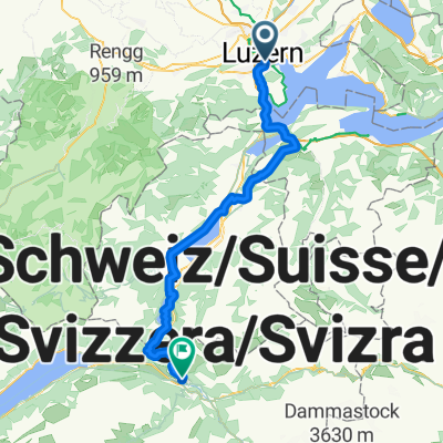
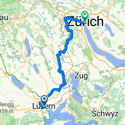
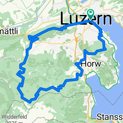
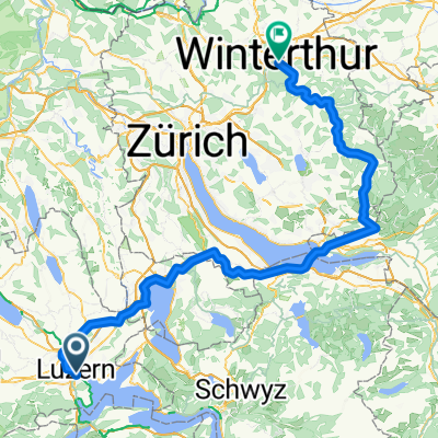
luzern rr schwarzenb glaubenbergpass sarnen ennetb bürgenst luzern 123 2700
A cycling route starting in Lucerne, Canton of Lucerne, Switzerland.
Overview
About this route
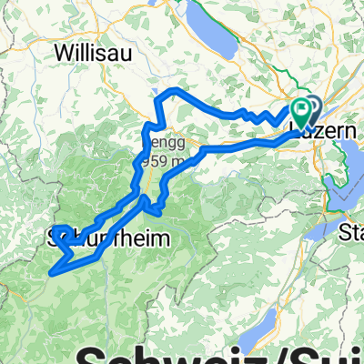
it may not be allowed to ride north of the Trogenalp/Bürgenstock golf course, check with anspr tour, the ascent to Bürgenstock is steepest for about 5 km, beautiful panoramas at Bürgenstock: the gradient is 10 to 12% over the entire route and only eases in the few hairpin bends
- -:--
- Duration
- 123.2 km
- Distance
- 2,300 m
- Ascent
- 2,300 m
- Descent
- ---
- Avg. speed
- ---
- Max. altitude
Route quality
Waytypes & surfaces along the route
Waytypes
Road
54.2 km
(44 %)
Quiet road
35.7 km
(29 %)
Surfaces
Paved
50.5 km
(41 %)
Unpaved
3.7 km
(3 %)
Asphalt
50.5 km
(41 %)
Unpaved (undefined)
1.2 km
(1 %)
Continue with Bikemap
Use, edit, or download this cycling route
You would like to ride luzern rr schwarzenb glaubenbergpass sarnen ennetb bürgenst luzern 123 2700 or customize it for your own trip? Here is what you can do with this Bikemap route:
Free features
- Save this route as favorite or in collections
- Copy & plan your own version of this route
- Split it into stages to create a multi-day tour
- Sync your route with Garmin or Wahoo
Premium features
Free trial for 3 days, or one-time payment. More about Bikemap Premium.
- Navigate this route on iOS & Android
- Export a GPX / KML file of this route
- Create your custom printout (try it for free)
- Download this route for offline navigation
Discover more Premium features.
Get Bikemap PremiumFrom our community
Other popular routes starting in Lucerne
Luzern - Küssnacht- Distance
- 14.8 km
- Ascent
- 314 m
- Descent
- 295 m
- Location
- Lucerne, Canton of Lucerne, Switzerland
Luzern - Obernau - Fräki - Luzern- Distance
- 23.8 km
- Ascent
- 1,014 m
- Descent
- 1,015 m
- Location
- Lucerne, Canton of Lucerne, Switzerland
halb um den 4waldstättersee- Distance
- 87.5 km
- Ascent
- 1,604 m
- Descent
- 1,596 m
- Location
- Lucerne, Canton of Lucerne, Switzerland
Rigi-Scheidegg- Distance
- 79.8 km
- Ascent
- 1,299 m
- Descent
- 1,299 m
- Location
- Lucerne, Canton of Lucerne, Switzerland
Rotkreuz-Meierskappel-Küssnacht-Udligenswil-Adligenswil- Distance
- 35 km
- Ascent
- 357 m
- Descent
- 355 m
- Location
- Lucerne, Canton of Lucerne, Switzerland
Vierwaldstättersee Tour- Distance
- 98.8 km
- Ascent
- 828 m
- Descent
- 827 m
- Location
- Lucerne, Canton of Lucerne, Switzerland
Luzern - Kehrsitenbürgenstock- Distance
- 15.1 km
- Ascent
- 317 m
- Descent
- 346 m
- Location
- Lucerne, Canton of Lucerne, Switzerland
Challenge Tour: Lucerne -> Rapperswil- Distance
- 98.8 km
- Ascent
- 846 m
- Descent
- 859 m
- Location
- Lucerne, Canton of Lucerne, Switzerland
Open it in the app

