

Bucklige Welt Runde 27.08.2016
A cycling route starting in Neunkirchen, Lower Austria, Austria.
Overview
About this route
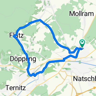
Start and finish of the tour in Peisching at the Dorfwirt at the foot of the Stork's Nest:
The first 25 km are flat, passing through Breitenau, Schwarzau am Steinfelde, Föhrenau, past the Linsberg thermal baths in Bad Erlach and the rose garden in Pitten to Seebenstein. Along the EURO VELO 9 cycle route (Polish Baltic coast - Croatian Adriatic), Türkensturz to Scheiblingkirchen.
From there, turn left into the side valley to Thernberg, where the first climb awaits via Schlag to Kaltenberg (about 7.2 km, 450 m elevation gain and 6% gradient). In Thernberg, there are cozy inns and also a private brewery called Wolfsbräu.
Once at the top, with the wind farm to the left, the route follows the ridge of the Bucklige Welt along partly lonely narrow country roads, with some short ups and downs and unique panoramic views (Wechsel, Schneeberg, Rax, Hohe Wand). Passing the pilgrimage church of Maria Schnee, Pregart, Amlos, Wiesfleck, and the White Cross to the Eis-Greissler ice cream manufactory. Refreshed with delicious homemade farm ice cream, there is a short climb to Kulma over the South Motorway A2 (approx. 3 km, 130 m elevation, 5%). Then a short steep descent with tight curves to Aspang.
Through the town of Aspang, the route then climbs beautifully to the ski resort of St. Corona am Wechsel at about 850 meters above sea level (approximately 6.3 km, 350 m elevation gain and 6%). Once at the top, it descends with some nice switchbacks towards Kirchberg am Wechsel.
Shortened variant: Those who want to skip the climb to St. Corona am Wechsel can head from Aspang towards Vienna and before Olbersdorf turn left into the Feistritz valley towards Kirchberg am Wechsel to start the stage (saving about 300 m elevation). Additionally, the climb from Eis-Greissler via Kulma to Aspang via Edlitz could also be bypassed, saving another 130 m. The route length remains unchanged.
At the end of Kirchberg am Wechsel, the ascent to Ramssattel awaits on the right at about 850 meters above sea level (about 4 km, 230 m elevation gain and 6%). A nice climb with some turns in the forest up to the Ramswirt. There, you can recharge your batteries with delicious products from the farm.
From Ramswirt, the route proceeds towards Penk. First, there is a short 30-meter climb to overcome, then the last 15 kilometers are mostly downhill via Penk, Neunkirchen, Natschbach, and Loipersbach to Peisching, the destination of our round.
For those who haven't had enough yet, there are numerous other alternative routes to collect additional kilometers and elevation meters.
For example:
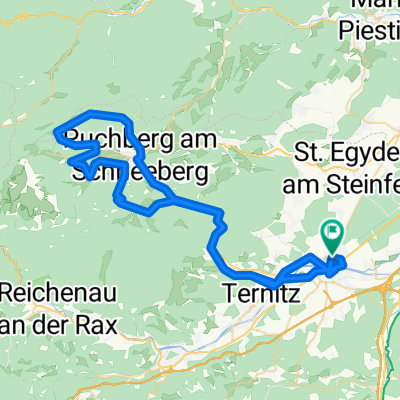
About 10 km and 100 m more: from Ramswirt towards Gloggnitz, Stuppach, Hundsberg (living up to its name - gradient up to 27%), Buchbach, Pottschach, Ternitz and flat to the finish in Peisching.
Or about 20 kilometers and 300 m more: from Ramswirt instead of heading to Penk, downhill to Kranichberg Castle to Gloggnitz. Then past the foot of the new Semmering tunnel portal and afterwards uphill to the plateau "auf der Wiese und Gasteil"... beautiful panoramic view towards the Wiener Neustadt Basin. Then downhill towards Termitz and flat to the finish in Peisching.
Or about 35 kilometers and 600 m more: from Ramswirt to Gloggnitz, uphill via Adlitzgraben to Breitenstein, through the famous "Ritter von Ghega" railway viaducts of the Semmeringbahn to the spa resort Semmering and the downhill MTB trail at over 1000 meters above sea level, then downhill past the pilgrimage site Maria Schutz to Schottwien. Flat (slightly descending) about 20 km to Gloggnitz, Neunkirchen, Peisching.
Have fun.
- -:--
- Duration
- 94.3 km
- Distance
- 1,420 m
- Ascent
- 1,420 m
- Descent
- ---
- Avg. speed
- ---
- Max. altitude
Route quality
Waytypes & surfaces along the route
Waytypes
Road
21.7 km
(23 %)
Quiet road
13.2 km
(14 %)
Surfaces
Paved
63.2 km
(67 %)
Asphalt
62.2 km
(66 %)
Paved (undefined)
0.9 km
(1 %)
Undefined
31.1 km
(33 %)
Continue with Bikemap
Use, edit, or download this cycling route
You would like to ride Bucklige Welt Runde 27.08.2016 or customize it for your own trip? Here is what you can do with this Bikemap route:
Free features
- Save this route as favorite or in collections
- Copy & plan your own version of this route
- Split it into stages to create a multi-day tour
- Sync your route with Garmin or Wahoo
Premium features
Free trial for 3 days, or one-time payment. More about Bikemap Premium.
- Navigate this route on iOS & Android
- Export a GPX / KML file of this route
- Create your custom printout (try it for free)
- Download this route for offline navigation
Discover more Premium features.
Get Bikemap PremiumFrom our community
Other popular routes starting in Neunkirchen
 Plonnergasse 13, Neunkirchen nach Plonnergasse 11, Neunkirchen
- Distance
- 17.6 km
- Ascent
- 143 m
- Descent
- 158 m
- Location
- Neunkirchen, Lower Austria, Austria
 Lichtenegg-Runde 1
- Distance
- 65.2 km
- Ascent
- 882 m
- Descent
- 879 m
- Location
- Neunkirchen, Lower Austria, Austria
 „über‘s Wasser“ nach Puchberg (Cyclocross)
- Distance
- 16.5 km
- Ascent
- 464 m
- Descent
- 314 m
- Location
- Neunkirchen, Lower Austria, Austria
 Grillenberg-Strecke
- Distance
- 51.6 km
- Ascent
- 664 m
- Descent
- 660 m
- Location
- Neunkirchen, Lower Austria, Austria
 Schneebergrunde
- Distance
- 68.9 km
- Ascent
- 881 m
- Descent
- 881 m
- Location
- Neunkirchen, Lower Austria, Austria
 Neunkirchen Schönfeld
- Distance
- 437.4 km
- Ascent
- 1,186 m
- Descent
- 1,399 m
- Location
- Neunkirchen, Lower Austria, Austria
 St.Corona Runde und bromberg
- Distance
- 77.8 km
- Ascent
- 1,150 m
- Descent
- 1,153 m
- Location
- Neunkirchen, Lower Austria, Austria
 Heimatausflug 1
- Distance
- 118.4 km
- Ascent
- 1,808 m
- Descent
- 1,808 m
- Location
- Neunkirchen, Lower Austria, Austria
Open it in the app