

Bures Campsite
A cycling route starting in Colchester, England, United Kingdom.
Overview
About this route
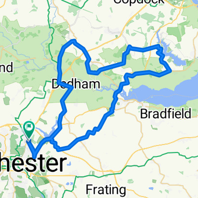
MEETING POINT: B&Q ROUNDABOUT
-
At the B&Q Roundabout, go down Hawkins Road, making sure to follow National Cycle Route 51. At the end of Hawkins Road, you should turn left.
-
Once finished National Cycle Route 51, you should turn left onto Cycle Route 1 after crossing the bridge at Castle Park. You should now be on Pavilion View.
-
Follow Cycle Route 1 back down, crossing the River Colne and arriving on Middle Mill.
-
Keeping on Cycle Route 1, you should now arrive on the High Street. Turn Right up the highstreet still following the Cycle Route.
-
Once at the top of the High Street, cross over North Hill onto Balkerine Passage, still following Cycle Route 1. Follow the road down until you reach the Bridge that goes over the A134. You should cross this.
-
Once on Popes Ln, turn left onto Crowhurst Road, following down until you see papillon Road where you turn Right into.
-
Still following Route 1, turn left into Rawston Road and follow down until you reach Southway (A1224). There should be a cycle path on the side of the road.
-
You should follow this down for a short amount of time, turning into Norman way once passed St Marys School on the Right. You should still be on Cycle Route 1.
-
Follow Cycle Route 1 down into Lexden, going through Beech Hill, down Church Road, Heath Road, straight road and Clairmont Road (going through a field). After, you should turn Right onto Cycle Route 13.
-
Follow down New Farm Road, crossing London Road (at the zedbra crossing) and heading down King Coel Road still on Cycle route 13.
-
Turn left into Halstead road, crossing over the top of the A12 and then turn right onto Chitts Hill after crossing.
-
Chitts hill should be followed keeping an eye out for Cycle route 13 numbers to help navigate.
-
After a long ride down Chitts hill, turn left into Argents Lane. You should see the River Colne approaching before this.
-
Argents Lane will transfer into Heath Road, keep following that as usual, turning right at Wood lane and left straight after at Fiddlers Hill.
-
Passing the River Colne, the road should change into Mill Road. This is all still Cycle route 13.
-
Mill road then changes into Church Road. Keep following it down into Fordham. Then carry on up Moat Road there after.
-
Turn Right into Chappel Road after exiting Fordham which will then transfer into Bridge hill. Keep going down this road. It should be pretty long.
-
Following route 13, turn right once the road ends. You should now be on Fordham Road which will later transfer to Roberts Hill.
-
still following route 13, at the end of Roberts hill, turn left and follow until you reach Hall Road.
-
At Hall Road, turn Right passing the Thachers Arms. You should carry straight on up this road until you reach the final part of the B1508 (Colchester Road) where you turn left. You should still be on Route 13.
-
Follow up until you reach Bridge street, where you turn right into.
-
Turn left once reached Church Square/High Street at the end of Bridge Street Follow that road until you see "The Croft" on your left. Turn down there and Bures scout hut should be on that road.
#ALL DONE USING CYCLE LANES 51,1 AND 13#
- -:--
- Duration
- 25.5 km
- Distance
- 133 m
- Ascent
- 115 m
- Descent
- ---
- Avg. speed
- ---
- Max. altitude

Route quality
Waytypes & surfaces along the route
Waytypes
Quiet road
11 km
(43 %)
Road
8.2 km
(32 %)
Surfaces
Paved
7.1 km
(28 %)
Unpaved
1 km
(4 %)
Asphalt
6.6 km
(26 %)
Unpaved (undefined)
0.5 km
(2 %)
Continue with Bikemap
Use, edit, or download this cycling route
You would like to ride Bures Campsite or customize it for your own trip? Here is what you can do with this Bikemap route:
Free features
- Save this route as favorite or in collections
- Copy & plan your own version of this route
- Sync your route with Garmin or Wahoo
Premium features
Free trial for 3 days, or one-time payment. More about Bikemap Premium.
- Navigate this route on iOS & Android
- Export a GPX / KML file of this route
- Create your custom printout (try it for free)
- Download this route for offline navigation
Discover more Premium features.
Get Bikemap PremiumFrom our community
Other popular routes starting in Colchester
 EA24: Day 2 Colchester - Felixstowe
- Distance
- 82.9 km
- Ascent
- 415 m
- Descent
- 424 m
- Location
- Colchester, England, United Kingdom
 Manningtree/Flatford2
- Distance
- 54.1 km
- Ascent
- 154 m
- Descent
- 152 m
- Location
- Colchester, England, United Kingdom
 Col to Harwich loop46
- Distance
- 74.4 km
- Ascent
- 235 m
- Descent
- 235 m
- Location
- Colchester, England, United Kingdom
 Colchester to Harwich Loop
- Distance
- 71.9 km
- Ascent
- 336 m
- Descent
- 375 m
- Location
- Colchester, England, United Kingdom
 sunday 14th
- Distance
- 67.3 km
- Ascent
- 189 m
- Descent
- 190 m
- Location
- Colchester, England, United Kingdom
 Bures Campsite
- Distance
- 25.5 km
- Ascent
- 133 m
- Descent
- 115 m
- Location
- Colchester, England, United Kingdom
 Horkesley, the Tey's & the Layer's Loop
- Distance
- 62.7 km
- Ascent
- 181 m
- Descent
- 184 m
- Location
- Colchester, England, United Kingdom
 Alton Water
- Distance
- 57.3 km
- Ascent
- 216 m
- Descent
- 215 m
- Location
- Colchester, England, United Kingdom
Open it in the app