

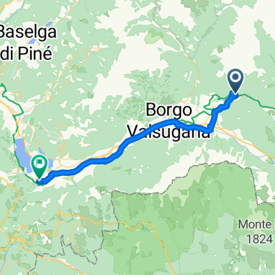
31 luglio
A cycling route starting in Bieno, Trentino-Alto Adige, Italy.
Overview
About this route
Alla conquista di Cima D'Asta
- -:--
- Duration
- 23.7 km
- Distance
- 2,338 m
- Ascent
- 2,357 m
- Descent
- ---
- Avg. speed
- ---
- Max. altitude

Route highlights
Points of interest along the route
Point of interest after 6.5 km
Malga Caldenave!!!!!
Continue with Bikemap
Use, edit, or download this cycling route
You would like to ride 31 luglio or customize it for your own trip? Here is what you can do with this Bikemap route:
Free features
- Save this route as favorite or in collections
- Copy & plan your own version of this route
- Sync your route with Garmin or Wahoo
Premium features
Free trial for 3 days, or one-time payment. More about Bikemap Premium.
- Navigate this route on iOS & Android
- Export a GPX / KML file of this route
- Create your custom printout (try it for free)
- Download this route for offline navigation
Discover more Premium features.
Get Bikemap PremiumFrom our community
Other popular routes starting in Bieno
 Pieve Tesino nach Via Resenterra, Lamon
- Distance
- 23.8 km
- Ascent
- 537 m
- Descent
- 795 m
- Location
- Bieno, Trentino-Alto Adige, Italy
 Day 03b - Bieno to Hotel Albergo Gilda
- Distance
- 31.3 km
- Ascent
- 265 m
- Descent
- 643 m
- Location
- Bieno, Trentino-Alto Adige, Italy
 cima d asta trek
- Distance
- 16.3 km
- Ascent
- 1,462 m
- Descent
- 1,469 m
- Location
- Bieno, Trentino-Alto Adige, Italy
 Giro 2024 c
- Distance
- 88.2 km
- Ascent
- 3,537 m
- Descent
- 3,532 m
- Location
- Bieno, Trentino-Alto Adige, Italy
 Bieno Cycling
- Distance
- 13.6 km
- Ascent
- 1,540 m
- Descent
- 1,534 m
- Location
- Bieno, Trentino-Alto Adige, Italy
 Tag_4_2_Alpencross_2014
- Distance
- 39 km
- Ascent
- 263 m
- Descent
- 1,701 m
- Location
- Bieno, Trentino-Alto Adige, Italy
 31 luglio
- Distance
- 23.7 km
- Ascent
- 2,338 m
- Descent
- 2,357 m
- Location
- Bieno, Trentino-Alto Adige, Italy
Open it in the app