

Herbringhauser Talsperre
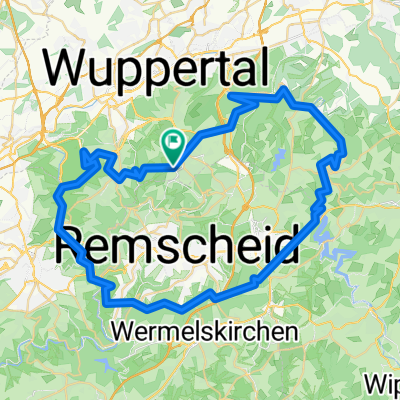
A cycling route starting in Remscheid, North Rhine-Westphalia, Germany.
Overview
About this route
Die Herbringhauser Talsperre ist eine Trinkwassertalsperre im Bergischen Land. Sie wurde von 1898 bis 1901 von der Stadt Barmen gebaut, die damals noch selbständig war und heute zu Wuppertal gehört. Gestaut wird der Herbringhauser Bach.
- -:--
- Duration
- 62.1 km
- Distance
- 154 m
- Ascent
- 442 m
- Descent
- ---
- Avg. speed
- ---
- Max. altitude

Route quality
Waytypes & surfaces along the route
Waytypes
Path
21 km
(34 %)
Quiet road
11.1 km
(18 %)
Surfaces
Paved
41.6 km
(67 %)
Unpaved
11.5 km
(19 %)
Asphalt
35.9 km
(58 %)
Gravel
10.9 km
(17 %)
Route highlights
Points of interest along the route

Photo after 5.5 km
Die Herbringhauser Talsperre (bis 2006 „Obere Herbringhauser Talsperre“) ist eine Trinkwassertalsperre im Bergischen Land

Photo after 5.5 km
Die Herbringhauser Talsperre ist eine Trinkwassertalsperre im Bergischen Land.

Photo after 7.3 km
Der Herbringhauser Bach ist ein 7,103 Kilometer[3] langer Bach und ein Zufluss der Wupper, der seine Quelle in Remscheid nahe der Stadtgrenze zu Wuppertal hat.

Photo after 15.9 km
Die Nordbahntrasse in Wuppertal gehört zu den ambitioniertesten Bahntrassenwegeprojekten in Nordrhein-Westfalen

Photo after 20.8 km
Die Nordbahntrasse in Wuppertal gehört zu den ambitioniertesten Bahntrassenwegeprojekten in Nordrhein-Westfalen

Photo after 39.4 km
Hühnerbach in Haan

Photo after 45.2 km
Erholungsgebiet Unterbacher See

Photo after 52.6 km
Itterbach
Continue with Bikemap
Use, edit, or download this cycling route
You would like to ride Herbringhauser Talsperre or customize it for your own trip? Here is what you can do with this Bikemap route:
Free features
- Save this route as favorite or in collections
- Copy & plan your own version of this route
- Sync your route with Garmin or Wahoo
Premium features
Free trial for 3 days, or one-time payment. More about Bikemap Premium.
- Navigate this route on iOS & Android
- Export a GPX / KML file of this route
- Create your custom printout (try it for free)
- Download this route for offline navigation
Discover more Premium features.
Get Bikemap PremiumFrom our community
Other popular routes starting in Remscheid
 Rund um Remscheid2
- Distance
- 48.9 km
- Ascent
- 815 m
- Descent
- 826 m
- Location
- Remscheid, North Rhine-Westphalia, Germany
 Hausrunde Neu
- Distance
- 25.2 km
- Ascent
- 279 m
- Descent
- 280 m
- Location
- Remscheid, North Rhine-Westphalia, Germany
 30 Km um die Wuppersperre
- Distance
- 29.3 km
- Ascent
- 394 m
- Descent
- 394 m
- Location
- Remscheid, North Rhine-Westphalia, Germany
 73 Km durchs Bergische Land
- Distance
- 73.9 km
- Ascent
- 726 m
- Descent
- 744 m
- Location
- Remscheid, North Rhine-Westphalia, Germany
 Große MTB Burgholz
- Distance
- 62.1 km
- Ascent
- 1,036 m
- Descent
- 1,106 m
- Location
- Remscheid, North Rhine-Westphalia, Germany
 Adler Permanente 40 km
- Distance
- 39.3 km
- Ascent
- 470 m
- Descent
- 476 m
- Location
- Remscheid, North Rhine-Westphalia, Germany
 Remscheid - Kürten - Wipperfürth - Hückeswagen - Remscheid
- Distance
- 55.8 km
- Ascent
- 725 m
- Descent
- 750 m
- Location
- Remscheid, North Rhine-Westphalia, Germany
 Rund in Lüttringhausen
- Distance
- 7.6 km
- Ascent
- 94 m
- Descent
- 126 m
- Location
- Remscheid, North Rhine-Westphalia, Germany
Open it in the app