
VTT
Urepel - Irouléguy
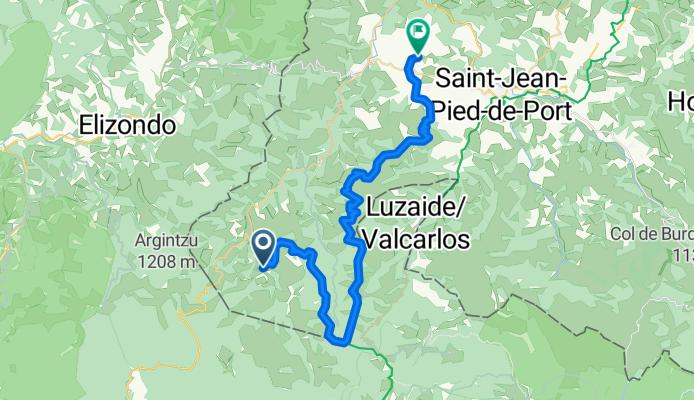
A cycling route starting in Saint-Étienne-de-Baïgorry, Nouvelle-Aquitaine, France.
Overview
About this route
Ridge lines between Urepel and Anhaux up to Irouléguy.
- -:--
- Duration
- 42.3 km
- Distance
- 1,241 m
- Ascent
- 1,392 m
- Descent
- ---
- Avg. speed
- ---
- Max. altitude

Part of
VTT
3 stages
Route photos


Route quality
Waytypes & surfaces along the route
Waytypes
Quiet road
14.4 km
(34 %)
Track
11 km
(26 %)
Surfaces
Paved
3.4 km
(8 %)
Unpaved
3 km
(7 %)
Paved (undefined)
3.4 km
(8 %)
Unpaved (undefined)
2.5 km
(6 %)
Route highlights
Points of interest along the route
Drinking water after 7.2 km
Point d'eau
Continue with Bikemap
Use, edit, or download this cycling route
You would like to ride Urepel - Irouléguy or customize it for your own trip? Here is what you can do with this Bikemap route:
Free features
- Save this route as favorite or in collections
- Copy & plan your own version of this route
- Sync your route with Garmin or Wahoo
Premium features
Free trial for 3 days, or one-time payment. More about Bikemap Premium.
- Navigate this route on iOS & Android
- Export a GPX / KML file of this route
- Create your custom printout (try it for free)
- Download this route for offline navigation
Discover more Premium features.
Get Bikemap PremiumFrom our community
Other popular routes starting in Saint-Étienne-de-Baïgorry
 2. Tag Saint Etienne - Etsaut
- Distance
- 157.5 km
- Ascent
- 5,114 m
- Descent
- 4,166 m
- Location
- Saint-Étienne-de-Baïgorry, Nouvelle-Aquitaine, France
 Urepel - Lindux - Ibañeta
- Distance
- 16.5 km
- Ascent
- 1,065 m
- Descent
- 371 m
- Location
- Saint-Étienne-de-Baïgorry, Nouvelle-Aquitaine, France
 Saint-Etienne-de-Baïgorry - Errozate
- Distance
- 101.5 km
- Ascent
- 4,610 m
- Descent
- 3,480 m
- Location
- Saint-Étienne-de-Baïgorry, Nouvelle-Aquitaine, France
 Bicitour2016-3b
- Distance
- 91.8 km
- Ascent
- 803 m
- Descent
- 895 m
- Location
- Saint-Étienne-de-Baïgorry, Nouvelle-Aquitaine, France
 Aldudes - Ehunzaroy
- Distance
- 149.2 km
- Ascent
- 4,078 m
- Descent
- 3,469 m
- Location
- Saint-Étienne-de-Baïgorry, Nouvelle-Aquitaine, France
 Bicitour2016-3
- Distance
- 84.9 km
- Ascent
- 1,781 m
- Descent
- 1,916 m
- Location
- Saint-Étienne-de-Baïgorry, Nouvelle-Aquitaine, France
 Jakobsweg Camino Francés Etappe 3
- Distance
- 99.5 km
- Ascent
- 1,697 m
- Descent
- 1,692 m
- Location
- Saint-Étienne-de-Baïgorry, Nouvelle-Aquitaine, France
 Urepel - Irouléguy
- Distance
- 42.3 km
- Ascent
- 1,241 m
- Descent
- 1,392 m
- Location
- Saint-Étienne-de-Baïgorry, Nouvelle-Aquitaine, France
Open it in the app