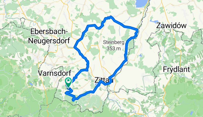
Rund um den Eigen
A cycling route starting in Großschönau, Saxony, Germany.
Overview
About this route
Hilly tour through the far eastern part of Saxony. First through the Zittau Mountains, then follow the Neisse river to Ostritz. Through fields and meadows over Bernstadt to Herrnhut. Back over the foothills of Kottmars into the Mandau Valley.
- -:--
- Duration
- 79.8 km
- Distance
- 738 m
- Ascent
- 784 m
- Descent
- ---
- Avg. speed
- 464 m
- Max. altitude
Route quality
Waytypes & surfaces along the route
Waytypes
Road
23.1 km
(29 %)
Quiet road
13.6 km
(17 %)
Surfaces
Paved
47.1 km
(59 %)
Unpaved
1.6 km
(2 %)
Asphalt
47.1 km
(59 %)
Unpaved (undefined)
0.8 km
(1 %)
Continue with Bikemap
Use, edit, or download this cycling route
You would like to ride Rund um den Eigen or customize it for your own trip? Here is what you can do with this Bikemap route:
Free features
- Save this route as favorite or in collections
- Copy & plan your own version of this route
- Sync your route with Garmin or Wahoo
Premium features
Free trial for 3 days, or one-time payment. More about Bikemap Premium.
- Navigate this route on iOS & Android
- Export a GPX / KML file of this route
- Create your custom printout (try it for free)
- Download this route for offline navigation
Discover more Premium features.
Get Bikemap PremiumFrom our community
Other popular routes starting in Großschönau
- Rauchberg
- Distance
- 28.5 km
- Ascent
- 370 m
- Descent
- 202 m
- Location
- Großschönau, Saxony, Germany
- Test
- Distance
- 12.8 km
- Ascent
- 144 m
- Descent
- 144 m
- Location
- Großschönau, Saxony, Germany
- Variante Waltersdorf
- Distance
- 36.2 km
- Ascent
- 407 m
- Descent
- 408 m
- Location
- Großschönau, Saxony, Germany
- Zittauer Gebirge
- Distance
- 28.6 km
- Ascent
- 293 m
- Descent
- 210 m
- Location
- Großschönau, Saxony, Germany
- Großschönau - Liberec
- Distance
- 91.7 km
- Ascent
- 1,047 m
- Descent
- 1,052 m
- Location
- Großschönau, Saxony, Germany
- Noční přejezd Lužiček 2013-10-18
- Distance
- 57.4 km
- Ascent
- 863 m
- Descent
- 929 m
- Location
- Großschönau, Saxony, Germany
- Tour de Oppes, RTF Oberlausitz
- Distance
- 115.6 km
- Ascent
- 1,261 m
- Descent
- 1,212 m
- Location
- Großschönau, Saxony, Germany
- Großschönau > Bad Schandau > Großschönau
- Distance
- 105.2 km
- Ascent
- 920 m
- Descent
- 920 m
- Location
- Großschönau, Saxony, Germany
Open it in the app