

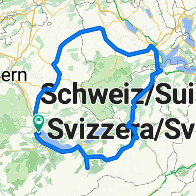
Thun-Blume-Thun by hm
A cycling route starting in Thun, Canton of Bern, Switzerland.
Overview
About this route
- -:--
- Duration
- 33.3 km
- Distance
- 1,070 m
- Ascent
- 1,069 m
- Descent
- ---
- Avg. speed
- ---
- Max. altitude

Continue with Bikemap
Use, edit, or download this cycling route
You would like to ride Thun-Blume-Thun by hm or customize it for your own trip? Here is what you can do with this Bikemap route:
Free features
- Save this route as favorite or in collections
- Copy & plan your own version of this route
- Sync your route with Garmin or Wahoo
Premium features
Free trial for 3 days, or one-time payment. More about Bikemap Premium.
- Navigate this route on iOS & Android
- Export a GPX / KML file of this route
- Create your custom printout (try it for free)
- Download this route for offline navigation
Discover more Premium features.
Get Bikemap PremiumFrom our community
Other popular routes starting in Thun
 Alpine Tour: Thun (day off)
- Distance
- 1.7 km
- Ascent
- 20 m
- Descent
- 17 m
- Location
- Thun, Canton of Bern, Switzerland
 Thun - Willisau
- Distance
- 249 km
- Ascent
- 8,115 m
- Descent
- 8,117 m
- Location
- Thun, Canton of Bern, Switzerland
 Martinstrasse, Thun nach Belpbergstrasse, Münsingen
- Distance
- 32.5 km
- Ascent
- 156 m
- Descent
- 195 m
- Location
- Thun, Canton of Bern, Switzerland
 Alpine Tour: Thun - Fluhli
- Distance
- 47.7 km
- Ascent
- 1,186 m
- Descent
- 640 m
- Location
- Thun, Canton of Bern, Switzerland
 Martinstrasse, Thun nach Rubigen
- Distance
- 28.3 km
- Ascent
- 122 m
- Descent
- 173 m
- Location
- Thun, Canton of Bern, Switzerland
 Mittwoch Abend Route In Thun
- Distance
- 10 km
- Ascent
- 252 m
- Descent
- 257 m
- Location
- Thun, Canton of Bern, Switzerland
 JE6: Thun, Freiburg, Moudon, Lausanne
- Distance
- 118.4 km
- Ascent
- 1,255 m
- Descent
- 1,459 m
- Location
- Thun, Canton of Bern, Switzerland
 Route nach Interlaken
- Distance
- 28.3 km
- Ascent
- 463 m
- Descent
- 459 m
- Location
- Thun, Canton of Bern, Switzerland
Open it in the app