

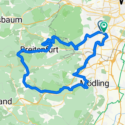
Raach h-flach
A cycling route starting in Perchtoldsdorf, Lower Austria, Austria.
Overview
About this route
Raach h-flach
- -:--
- Duration
- 80.3 km
- Distance
- 638 m
- Ascent
- 58 m
- Descent
- ---
- Avg. speed
- ---
- Max. altitude
Route quality
Waytypes & surfaces along the route
Waytypes
Cycleway
32.1 km
(40 %)
Quiet road
24.1 km
(30 %)
Surfaces
Paved
56.2 km
(70 %)
Unpaved
12.1 km
(15 %)
Asphalt
55.4 km
(69 %)
Unpaved (undefined)
4 km
(5 %)
Continue with Bikemap
Use, edit, or download this cycling route
You would like to ride Raach h-flach or customize it for your own trip? Here is what you can do with this Bikemap route:
Free features
- Save this route as favorite or in collections
- Copy & plan your own version of this route
- Split it into stages to create a multi-day tour
- Sync your route with Garmin or Wahoo
Premium features
Free trial for 3 days, or one-time payment. More about Bikemap Premium.
- Navigate this route on iOS & Android
- Export a GPX / KML file of this route
- Create your custom printout (try it for free)
- Download this route for offline navigation
Discover more Premium features.
Get Bikemap PremiumFrom our community
Other popular routes starting in Perchtoldsdorf
 über 7 Hügel
- Distance
- 58.5 km
- Ascent
- 939 m
- Descent
- 889 m
- Location
- Perchtoldsdorf, Lower Austria, Austria
 Lainzer Tiergarten Runde
- Distance
- 31.9 km
- Ascent
- 627 m
- Descent
- 627 m
- Location
- Perchtoldsdorf, Lower Austria, Austria
 Wienerwald-Schmankerl
- Distance
- 44.3 km
- Ascent
- 723 m
- Descent
- 721 m
- Location
- Perchtoldsdorf, Lower Austria, Austria
 Parapulie Strecke
- Distance
- 32 km
- Ascent
- 723 m
- Descent
- 723 m
- Location
- Perchtoldsdorf, Lower Austria, Austria
 Liesing - Rodaun - Heide - Liesing
- Distance
- 16.7 km
- Ascent
- 264 m
- Descent
- 261 m
- Location
- Perchtoldsdorf, Lower Austria, Austria
 elg:// Doktorberg-Strecke
- Distance
- 13.2 km
- Ascent
- 322 m
- Descent
- 322 m
- Location
- Perchtoldsdorf, Lower Austria, Austria
 Große Runde um den lainzer Tierpark
- Distance
- 43.2 km
- Ascent
- 518 m
- Descent
- 514 m
- Location
- Perchtoldsdorf, Lower Austria, Austria
 way home
- Distance
- 11.5 km
- Ascent
- 23 m
- Descent
- 41 m
- Location
- Perchtoldsdorf, Lower Austria, Austria
Open it in the app