
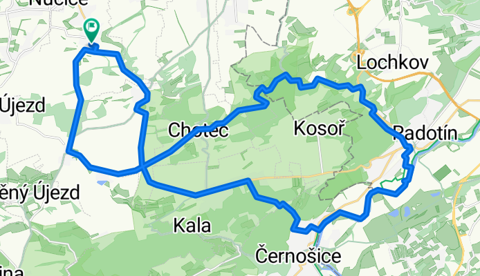
Tachlovice - Radotin
A cycling route starting in Rudná, Central Bohemia, Czechia.
Overview
About this route
Tachlovice - Trebotov - Sulava - Cernosice - Radotin Lazne - Radotin Cementarna - Mlyn u Veslych - Chotec - Kucharik - Kuchar - Tachlovice
- -:--
- Duration
- 30.9 km
- Distance
- 322 m
- Ascent
- 322 m
- Descent
- ---
- Avg. speed
- ---
- Max. altitude

Route quality
Waytypes & surfaces along the route
Waytypes
Road
6.2 km
(20 %)
Quiet road
5.3 km
(17 %)
Surfaces
Paved
12.1 km
(39 %)
Unpaved
5.6 km
(18 %)
Asphalt
11.1 km
(36 %)
Ground
3.1 km
(10 %)
Continue with Bikemap
Use, edit, or download this cycling route
You would like to ride Tachlovice - Radotin or customize it for your own trip? Here is what you can do with this Bikemap route:
Free features
- Save this route as favorite or in collections
- Copy & plan your own version of this route
- Sync your route with Garmin or Wahoo
Premium features
Free trial for 3 days, or one-time payment. More about Bikemap Premium.
- Navigate this route on iOS & Android
- Export a GPX / KML file of this route
- Create your custom printout (try it for free)
- Download this route for offline navigation
Discover more Premium features.
Get Bikemap PremiumFrom our community
Other popular routes starting in Rudná
 Rudenská
- Distance
- 37.7 km
- Ascent
- 566 m
- Descent
- 565 m
- Location
- Rudná, Central Bohemia, Czechia
 20180505
- Distance
- 28.8 km
- Ascent
- 254 m
- Descent
- 256 m
- Location
- Rudná, Central Bohemia, Czechia
 Zk 1
Zk 1- Distance
- 33.6 km
- Ascent
- 312 m
- Descent
- 311 m
- Location
- Rudná, Central Bohemia, Czechia
 Rudná-Karlík-Kuchař-Rudná
- Distance
- 49.9 km
- Ascent
- 903 m
- Descent
- 903 m
- Location
- Rudná, Central Bohemia, Czechia
 Rudná-Příbram-Mirošov-Hořovice-Rudná
- Distance
- 174.2 km
- Ascent
- 1,982 m
- Descent
- 2,074 m
- Location
- Rudná, Central Bohemia, Czechia
 Rudná-Lichoceves-Rudná-Roud
- Distance
- 58.3 km
- Ascent
- 348 m
- Descent
- 347 m
- Location
- Rudná, Central Bohemia, Czechia
 Tachlovice - Radotin
- Distance
- 30.9 km
- Ascent
- 322 m
- Descent
- 322 m
- Location
- Rudná, Central Bohemia, Czechia
 Tachlovice - Bubovice
- Distance
- 21.3 km
- Ascent
- 320 m
- Descent
- 322 m
- Location
- Rudná, Central Bohemia, Czechia
Open it in the app