

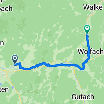
Hausach - Konstanz
A cycling route starting in Fischerbach, Baden-Württemberg, Germany.
Overview
About this route
Über:
Hornberg
Geisingen
Engen
- -:--
- Duration
- 121.9 km
- Distance
- ---
- Ascent
- ---
- Descent
- ---
- Avg. speed
- ---
- Avg. speed

Route quality
Waytypes & surfaces along the route
Waytypes
Quiet road
32.8 km
(27 %)
Road
23 km
(19 %)
Surfaces
Paved
102.7 km
(84 %)
Unpaved
10 km
(8 %)
Asphalt
96.3 km
(79 %)
Paved (undefined)
5.6 km
(5 %)
Continue with Bikemap
Use, edit, or download this cycling route
You would like to ride Hausach - Konstanz or customize it for your own trip? Here is what you can do with this Bikemap route:
Free features
- Save this route as favorite or in collections
- Copy & plan your own version of this route
- Split it into stages to create a multi-day tour
- Sync your route with Garmin or Wahoo
Premium features
Free trial for 3 days, or one-time payment. More about Bikemap Premium.
- Navigate this route on iOS & Android
- Export a GPX / KML file of this route
- Create your custom printout (try it for free)
- Download this route for offline navigation
Discover more Premium features.
Get Bikemap PremiumFrom our community
Other popular routes starting in Fischerbach
 Fischerbach Gifizsee
- Distance
- 61.6 km
- Ascent
- 210 m
- Descent
- 163 m
- Location
- Fischerbach, Baden-Württemberg, Germany
 Rund ums Einbachtal
- Distance
- 15.8 km
- Ascent
- 709 m
- Descent
- 698 m
- Location
- Fischerbach, Baden-Württemberg, Germany
 Rautsch - Löcherbergwasen
- Distance
- 19.4 km
- Ascent
- 738 m
- Descent
- 566 m
- Location
- Fischerbach, Baden-Württemberg, Germany
 Karl-May-Weg 22, Fischerbach nach Wolftalstraße 20, Oberwolfach
- Distance
- 13.7 km
- Ascent
- 226 m
- Descent
- 158 m
- Location
- Fischerbach, Baden-Württemberg, Germany
 KCU Wanderung 2011
- Distance
- 4.1 km
- Ascent
- 286 m
- Descent
- 397 m
- Location
- Fischerbach, Baden-Württemberg, Germany
 Planung Nill => Fischerbach
- Distance
- 7.6 km
- Ascent
- 75 m
- Descent
- 498 m
- Location
- Fischerbach, Baden-Württemberg, Germany
 Wolftal, Erzenbach, Bettelfrau, Steigleskopf
- Distance
- 36.8 km
- Ascent
- 793 m
- Descent
- 781 m
- Location
- Fischerbach, Baden-Württemberg, Germany
 20160522_134149.gpx
- Distance
- 27.7 km
- Ascent
- 170 m
- Descent
- 758 m
- Location
- Fischerbach, Baden-Württemberg, Germany
Open it in the app