

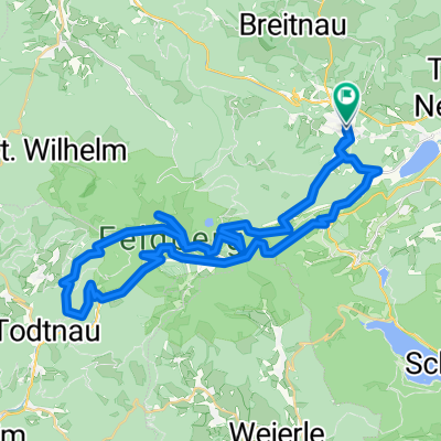
Hinterzarten - Feldsee
A cycling route starting in Hinterzarten, Baden-Württemberg, Germany.
Overview
About this route
Angenehme Tour von Hinterzarten aus über den Rinken zum Feldsee und zurück.
Einkehrmöglichkeit gibt es am Raimartihof in der Nähe des Feldsees.
- -:--
- Duration
- 30.1 km
- Distance
- 924 m
- Ascent
- 886 m
- Descent
- ---
- Avg. speed
- 1,231 m
- Max. altitude

Route quality
Waytypes & surfaces along the route
Waytypes
Track
21.6 km
(72 %)
Quiet road
8.4 km
(28 %)
Surfaces
Paved
8.5 km
(28 %)
Unpaved
21.6 km
(72 %)
Gravel
20.4 km
(68 %)
Asphalt
8.5 km
(28 %)
Continue with Bikemap
Use, edit, or download this cycling route
You would like to ride Hinterzarten - Feldsee or customize it for your own trip? Here is what you can do with this Bikemap route:
Free features
- Save this route as favorite or in collections
- Copy & plan your own version of this route
- Sync your route with Garmin or Wahoo
Premium features
Free trial for 3 days, or one-time payment. More about Bikemap Premium.
- Navigate this route on iOS & Android
- Export a GPX / KML file of this route
- Create your custom printout (try it for free)
- Download this route for offline navigation
Discover more Premium features.
Get Bikemap PremiumFrom our community
Other popular routes starting in Hinterzarten
 Südschwarzwald-Radweg
- Distance
- 266.4 km
- Ascent
- 1,219 m
- Descent
- 1,219 m
- Location
- Hinterzarten, Baden-Württemberg, Germany
 Rund um den Feldberg ...
- Distance
- 47.2 km
- Ascent
- 1,274 m
- Descent
- 1,273 m
- Location
- Hinterzarten, Baden-Württemberg, Germany
 47.893, 8.136 nach 47.864, 8.022
- Distance
- 16 km
- Ascent
- 682 m
- Descent
- 129 m
- Location
- Hinterzarten, Baden-Württemberg, Germany
 Black Forest Ultra Bike 42km
- Distance
- 40.1 km
- Ascent
- 753 m
- Descent
- 1,290 m
- Location
- Hinterzarten, Baden-Württemberg, Germany
 Idyllische Tour von Titiseeüber Bärental nach Hinterzarten
- Distance
- 18.3 km
- Ascent
- 370 m
- Descent
- 371 m
- Location
- Hinterzarten, Baden-Württemberg, Germany
 Titisee 1
- Distance
- 18.2 km
- Ascent
- 366 m
- Descent
- 366 m
- Location
- Hinterzarten, Baden-Württemberg, Germany
 Hinterzarten - Titisee - Bärenthal
- Distance
- 19.6 km
- Ascent
- 387 m
- Descent
- 379 m
- Location
- Hinterzarten, Baden-Württemberg, Germany
 Zartenbachweg, Hinterzarten nach Zartenbachweg, Hinterzarten
- Distance
- 31.5 km
- Ascent
- 577 m
- Descent
- 576 m
- Location
- Hinterzarten, Baden-Württemberg, Germany
Open it in the app