Duinger Wald-Wilhelm Rabbe Turm
A cycling route starting in Duingen, Lower Saxony, Germany.
Overview
About this route
Von Duingeb durch Duinger Wald, Bloße Zelle, Wilhelm Rabbe Turm, Roter Fuchs und zurück.
- -:--
- Duration
- 32.5 km
- Distance
- 434 m
- Ascent
- 432 m
- Descent
- ---
- Avg. speed
- ---
- Avg. speed
Route quality
Waytypes & surfaces along the route
Waytypes
Track
31.3 km
(96 %)
Path
1.2 km
(4 %)
Undefined
0 km
(<1 %)
Surfaces
Unpaved
32.3 km
(100 %)
Gravel
29.8 km
(92 %)
Ground
2.5 km
(8 %)
Continue with Bikemap
Use, edit, or download this cycling route
You would like to ride Duinger Wald-Wilhelm Rabbe Turm or customize it for your own trip? Here is what you can do with this Bikemap route:
Free features
- Save this route as favorite or in collections
- Copy & plan your own version of this route
- Sync your route with Garmin or Wahoo
Premium features
Free trial for 3 days, or one-time payment. More about Bikemap Premium.
- Navigate this route on iOS & Android
- Export a GPX / KML file of this route
- Create your custom printout (try it for free)
- Download this route for offline navigation
Discover more Premium features.
Get Bikemap PremiumFrom our community
Other popular routes starting in Duingen
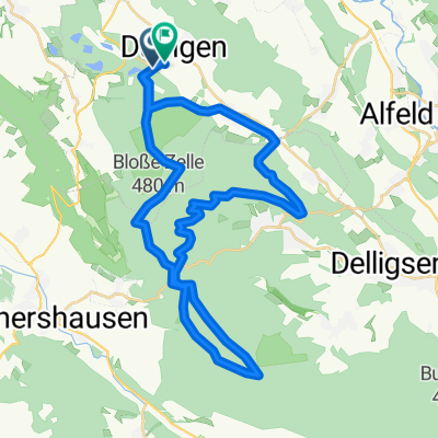
- um die Duinger Seeen
- Distance
- 22 km
- Ascent
- 196 m
- Descent
- 198 m
- Location
- Duingen, Lower Saxony, Germany
- Unter der Wulfseiche 30, Duingen nach Unter der Wulfseiche 30, Duingen
- Distance
- 7 km
- Ascent
- 73 m
- Descent
- 74 m
- Location
- Duingen, Lower Saxony, Germany
- Duingen-Lönsturm-Duingen
- Distance
- 22.1 km
- Ascent
- ---
- Descent
- ---
- Location
- Duingen, Lower Saxony, Germany
- 400-5
- Distance
- 65.7 km
- Ascent
- 505 m
- Descent
- 608 m
- Location
- Duingen, Lower Saxony, Germany
- Humboldsee Salhemendorf Rundweg
- Distance
- 33.1 km
- Ascent
- 668 m
- Descent
- 667 m
- Location
- Duingen, Lower Saxony, Germany
- Um die Ithwiesen
- Distance
- 18.4 km
- Ascent
- 288 m
- Descent
- 288 m
- Location
- Duingen, Lower Saxony, Germany
- Duinger Wald-Wilhelm Rabbe Turm
- Distance
- 32.5 km
- Ascent
- 434 m
- Descent
- 432 m
- Location
- Duingen, Lower Saxony, Germany
- Moderate Route in Duingen
- Distance
- 27.2 km
- Ascent
- 470 m
- Descent
- 480 m
- Location
- Duingen, Lower Saxony, Germany
Open it in the app