

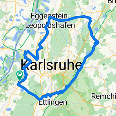
MB Rheinstetten- Hardtwald-Malsch-Waldprechtweier-Waldprechtstal-Maierbild-Um den Mahlberg-Althof-Moosbronn-Moosalbtal-Fichweier-Ettlingen-Rheinstetten
A cycling route starting in Rheinstetten, Baden-Württemberg, Germany.
Overview
About this route
Eine Tour der RadSportsenioren Rheinstetten.
schöne abwechslungsreiche Route mit schönen Anstiegen.
gefahren am 16.12.2009 von Norbert & Jürgen
gemessene Werte 64Km; 600Hm
- -:--
- Duration
- 58.2 km
- Distance
- 813 m
- Ascent
- 812 m
- Descent
- ---
- Avg. speed
- 476 m
- Max. altitude

Route quality
Waytypes & surfaces along the route
Waytypes
Track
15.3 km
(26 %)
Road
14.4 km
(25 %)
Surfaces
Paved
46.5 km
(80 %)
Unpaved
10.5 km
(18 %)
Asphalt
43.9 km
(75 %)
Gravel
5.2 km
(9 %)
Continue with Bikemap
Use, edit, or download this cycling route
You would like to ride MB Rheinstetten- Hardtwald-Malsch-Waldprechtweier-Waldprechtstal-Maierbild-Um den Mahlberg-Althof-Moosbronn-Moosalbtal-Fichweier-Ettlingen-Rheinstetten or customize it for your own trip? Here is what you can do with this Bikemap route:
Free features
- Save this route as favorite or in collections
- Copy & plan your own version of this route
- Sync your route with Garmin or Wahoo
Premium features
Free trial for 3 days, or one-time payment. More about Bikemap Premium.
- Navigate this route on iOS & Android
- Export a GPX / KML file of this route
- Create your custom printout (try it for free)
- Download this route for offline navigation
Discover more Premium features.
Get Bikemap PremiumFrom our community
Other popular routes starting in Rheinstetten
 Karlsruhe Heidelberg
- Distance
- 87.4 km
- Ascent
- 81 m
- Descent
- 85 m
- Location
- Rheinstetten, Baden-Württemberg, Germany
 RR -Verkehrsarme " Fünf Täler Rundtour" - Rheintal, Albtal, Eyachtal, Enztal & Murgtal.
- Distance
- 104.7 km
- Ascent
- 1,027 m
- Descent
- 1,029 m
- Location
- Rheinstetten, Baden-Württemberg, Germany
 durch das Murgtal nach Bermersbach, die Rote Lache über den Scherrhof nach Baden-Baden, Balg, Haueneberstein, Kuppenheim und Muggensturm nach Malsch und zurück
- Distance
- 98.7 km
- Ascent
- 678 m
- Descent
- 686 m
- Location
- Rheinstetten, Baden-Württemberg, Germany
 Rheinroute
- Distance
- 80.5 km
- Ascent
- 122 m
- Descent
- 123 m
- Location
- Rheinstetten, Baden-Württemberg, Germany
 Rund um die badische Residenz.
- Distance
- 64.9 km
- Ascent
- 161 m
- Descent
- 166 m
- Location
- Rheinstetten, Baden-Württemberg, Germany
 Siemensstraße 2B, Rheinstetten nach Berliner Allee 20, Stutensee
- Distance
- 24 km
- Ascent
- 86 m
- Descent
- 83 m
- Location
- Rheinstetten, Baden-Württemberg, Germany
 Radwallfahrt zur St. Annakapelle in Burrweiler mit Einkehrschwung im höchst gelegenen Weingut der Pfalz.
- Distance
- 110.6 km
- Ascent
- 464 m
- Descent
- 464 m
- Location
- Rheinstetten, Baden-Württemberg, Germany
 Frankreichrunde
- Distance
- 70.8 km
- Ascent
- 64 m
- Descent
- 66 m
- Location
- Rheinstetten, Baden-Württemberg, Germany
Open it in the app