

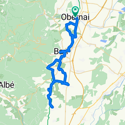
RSCN Obernai 2016 Fitnessgruppe Samstag
A cycling route starting in Obernai, Grand Est, France.
Overview
About this route
Obernai - Bischoffsheim - Griesheim-près-Molsheim - Innenheim - Blaesheim - Geispolsheim - Lipsheim - Fegersheim - Eschau- am Rhein/Rhone-Kanal entlang bis Erstein - Schaeffersheim - Bolsenheim - Uttenheim - Westhouse - Kertzfeld - Stotzheim - Saint-Pierre - Eichhoffen - Andlau - Mittelbegheim - Barr - Heiligenstein - - Bernardswiller - Ottrott - Obernai
- -:--
- Duration
- 79.4 km
- Distance
- 274 m
- Ascent
- 274 m
- Descent
- ---
- Avg. speed
- ---
- Max. altitude

Route quality
Waytypes & surfaces along the route
Waytypes
Road
18.3 km
(23 %)
Cycleway
13.5 km
(17 %)
Surfaces
Paved
42.9 km
(54 %)
Unpaved
1.6 km
(2 %)
Asphalt
42.9 km
(54 %)
Gravel
1.6 km
(2 %)
Undefined
35 km
(44 %)
Continue with Bikemap
Use, edit, or download this cycling route
You would like to ride RSCN Obernai 2016 Fitnessgruppe Samstag or customize it for your own trip? Here is what you can do with this Bikemap route:
Free features
- Save this route as favorite or in collections
- Copy & plan your own version of this route
- Sync your route with Garmin or Wahoo
Premium features
Free trial for 3 days, or one-time payment. More about Bikemap Premium.
- Navigate this route on iOS & Android
- Export a GPX / KML file of this route
- Create your custom printout (try it for free)
- Download this route for offline navigation
Discover more Premium features.
Get Bikemap PremiumFrom our community
Other popular routes starting in Obernai
 Elsass-Radtour Tag 7
- Distance
- 43.2 km
- Ascent
- 59 m
- Descent
- 96 m
- Location
- Obernai, Grand Est, France
 RSCN Obernai 2016 Fitnessgruppe Samstag
- Distance
- 79.4 km
- Ascent
- 274 m
- Descent
- 274 m
- Location
- Obernai, Grand Est, France
 Obernai Riquwihr
- Distance
- 47 km
- Ascent
- 495 m
- Descent
- 372 m
- Location
- Obernai, Grand Est, France
 vtt 1
vtt 1- Distance
- 22.5 km
- Ascent
- 750 m
- Descent
- 751 m
- Location
- Obernai, Grand Est, France
 BTR : départ
- Distance
- 14.9 km
- Ascent
- 618 m
- Descent
- 47 m
- Location
- Obernai, Grand Est, France
 Rue du Général Gouraud to Rue du Général Gouraud
- Distance
- 53.5 km
- Ascent
- 559 m
- Descent
- 559 m
- Location
- Obernai, Grand Est, France
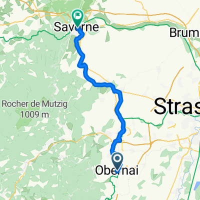 Elsass Tag 5 Obernai bis Saverne
- Distance
- 45.8 km
- Ascent
- 413 m
- Descent
- 408 m
- Location
- Obernai, Grand Est, France
 Runde um Obernai
- Distance
- 30 km
- Ascent
- 176 m
- Descent
- 178 m
- Location
- Obernai, Grand Est, France
Open it in the app