

20160728_083054.gpx
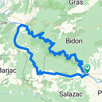
A cycling route starting in Saint-Julien-de-Peyrolas, Occitanie, France.
Overview
About this route
TEASI track
- -:--
- Duration
- 34.1 km
- Distance
- 743 m
- Ascent
- 740 m
- Descent
- ---
- Avg. speed
- ---
- Max. altitude
Route quality
Waytypes & surfaces along the route
Waytypes
Track
20.5 km
(60 %)
Quiet road
9.6 km
(28 %)
Road
4.1 km
(12 %)
Surfaces
Paved
1.4 km
(4 %)
Unpaved
8.5 km
(25 %)
Gravel
7.2 km
(21 %)
Paved (undefined)
1.4 km
(4 %)
Continue with Bikemap
Use, edit, or download this cycling route
You would like to ride 20160728_083054.gpx or customize it for your own trip? Here is what you can do with this Bikemap route:
Free features
- Save this route as favorite or in collections
- Copy & plan your own version of this route
- Sync your route with Garmin or Wahoo
Premium features
Free trial for 3 days, or one-time payment. More about Bikemap Premium.
- Navigate this route on iOS & Android
- Export a GPX / KML file of this route
- Create your custom printout (try it for free)
- Download this route for offline navigation
Discover more Premium features.
Get Bikemap PremiumFrom our community
Other popular routes starting in Saint-Julien-de-Peyrolas
 TGA25 Parcours Vélo dist.L
- Distance
- 76.9 km
- Ascent
- 3,184 m
- Descent
- 3,183 m
- Location
- Saint-Julien-de-Peyrolas, Occitanie, France
 Ardeche
- Distance
- 68.2 km
- Ascent
- 819 m
- Descent
- 807 m
- Location
- Saint-Julien-de-Peyrolas, Occitanie, France
 St-Julien Bastide Virac Barjac Monclus Salazac
- Distance
- 66.9 km
- Ascent
- 686 m
- Descent
- 689 m
- Location
- Saint-Julien-de-Peyrolas, Occitanie, France
 Roche guide
- Distance
- 69 km
- Ascent
- 346 m
- Descent
- 345 m
- Location
- Saint-Julien-de-Peyrolas, Occitanie, France
 Long bike tour through Laval-St.-Roman
- Distance
- 77.3 km
- Ascent
- 733 m
- Descent
- 733 m
- Location
- Saint-Julien-de-Peyrolas, Occitanie, France
 Triathlon des Gorges de l'Ardèche
- Distance
- 38.6 km
- Ascent
- 570 m
- Descent
- 525 m
- Location
- Saint-Julien-de-Peyrolas, Occitanie, France
 Suze Le Russe
- Distance
- 71.7 km
- Ascent
- 349 m
- Descent
- 348 m
- Location
- Saint-Julien-de-Peyrolas, Occitanie, France
 TGA25 Parcours CàP Jeunes 10/13
- Distance
- 1.6 km
- Ascent
- 29 m
- Descent
- 23 m
- Location
- Saint-Julien-de-Peyrolas, Occitanie, France
Open it in the app