

Tegernsee - Huberspitz - Gindelalmschneid - Neureuth
A cycling route starting in Tegernsee, Bavaria, Germany.
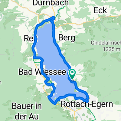
Overview
About this route
The route starts off with a steady uphill portion followed by a gradual descent towards Breitenbach. From there there is a tiny bit of pavement/road towards Abwinkl after which a difficult uphill section begins (after the large oak in the pictures).
From this point the only way is up until you reach the Huberspitz Alm and then it's much leaner towards the next 2 peaks.
After Neureuth there is a really technical rocky descent with lots of stress in the brakes. The trail ends back in Tegernsee close to the train station.
- -:--
- Duration
- 39.4 km
- Distance
- 1,422 m
- Ascent
- 1,435 m
- Descent
- ---
- Avg. speed
- ---
- Max. altitude

Route photos


Continue with Bikemap
Use, edit, or download this cycling route
You would like to ride Tegernsee - Huberspitz - Gindelalmschneid - Neureuth or customize it for your own trip? Here is what you can do with this Bikemap route:
Free features
- Save this route as favorite or in collections
- Copy & plan your own version of this route
- Sync your route with Garmin or Wahoo
Premium features
Free trial for 3 days, or one-time payment. More about Bikemap Premium.
- Navigate this route on iOS & Android
- Export a GPX / KML file of this route
- Create your custom printout (try it for free)
- Download this route for offline navigation
Discover more Premium features.
Get Bikemap PremiumFrom our community
Other popular routes starting in Tegernsee
 Seestraße 10, Tegernsee nach Schönwerthstraße 20–42, München
- Distance
- 49.9 km
- Ascent
- 302 m
- Descent
- 484 m
- Location
- Tegernsee, Bavaria, Germany
 Gindelalm
- Distance
- 11.8 km
- Ascent
- 635 m
- Descent
- 637 m
- Location
- Tegernsee, Bavaria, Germany
 Seestraße nach Bahnhofplatz
- Distance
- 25.1 km
- Ascent
- 226 m
- Descent
- 284 m
- Location
- Tegernsee, Bavaria, Germany
 Seerundweg Tegernsee (Tour Nr. 32 aus dem"RadlTraum Süd")
- Distance
- 20.9 km
- Ascent
- 139 m
- Descent
- 140 m
- Location
- Tegernsee, Bavaria, Germany
 Rundfahrt von Tegernsee Bhf über Kreuzberg
- Distance
- 5.8 km
- Ascent
- 530 m
- Descent
- 80 m
- Location
- Tegernsee, Bavaria, Germany
 Tegernsee /Schliersee
- Distance
- 45.8 km
- Ascent
- 1,674 m
- Descent
- 1,674 m
- Location
- Tegernsee, Bavaria, Germany
 21.6. München to Tegernsee
- Distance
- 90.1 km
- Ascent
- 742 m
- Descent
- 966 m
- Location
- Tegernsee, Bavaria, Germany
 22.6. Tegernsee - Maurach
- Distance
- 51.4 km
- Ascent
- 1,168 m
- Descent
- 969 m
- Location
- Tegernsee, Bavaria, Germany
Open it in the app