

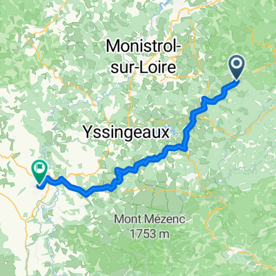
Huit St Julien Molhesabate - St Bonnet Le Froid - Rochepaule
A cycling route starting in Riotord, Auvergne-Rhône-Alpes, France.
Overview
About this route
- -:--
- Duration
- 55.8 km
- Distance
- 930 m
- Ascent
- 932 m
- Descent
- ---
- Avg. speed
- ---
- Max. altitude

Route photos


Route quality
Waytypes & surfaces along the route
Waytypes
Road
36.8 km
(66 %)
Quiet road
7.8 km
(14 %)
Surfaces
Unpaved
0.6 km
(1 %)
Ground
0.6 km
(1 %)
Undefined
55.2 km
(99 %)
Continue with Bikemap
Use, edit, or download this cycling route
You would like to ride Huit St Julien Molhesabate - St Bonnet Le Froid - Rochepaule or customize it for your own trip? Here is what you can do with this Bikemap route:
Free features
- Save this route as favorite or in collections
- Copy & plan your own version of this route
- Sync your route with Garmin or Wahoo
Premium features
Free trial for 3 days, or one-time payment. More about Bikemap Premium.
- Navigate this route on iOS & Android
- Export a GPX / KML file of this route
- Create your custom printout (try it for free)
- Download this route for offline navigation
Discover more Premium features.
Get Bikemap PremiumFrom our community
Other popular routes starting in Riotord
 Huit St Julien Molhesabate - St Bonnet Le Froid - Rochepaule
- Distance
- 55.8 km
- Ascent
- 930 m
- Descent
- 932 m
- Location
- Riotord, Auvergne-Rhône-Alpes, France
 Epicure 2015
- Distance
- 131.8 km
- Ascent
- 2,216 m
- Descent
- 2,234 m
- Location
- Riotord, Auvergne-Rhône-Alpes, France
 La Via Fluvia
- Distance
- 57.3 km
- Ascent
- 547 m
- Descent
- 855 m
- Location
- Riotord, Auvergne-Rhône-Alpes, France
 Les plateaux du Vivarais
- Distance
- 62.1 km
- Ascent
- 730 m
- Descent
- 730 m
- Location
- Riotord, Auvergne-Rhône-Alpes, France
 Tour du massif du Grand Felletin
- Distance
- 58.7 km
- Ascent
- 1,097 m
- Descent
- 1,097 m
- Location
- Riotord, Auvergne-Rhône-Alpes, France
 Riotord - Le Puy-en-Velay
- Distance
- 73.1 km
- Ascent
- 447 m
- Descent
- 750 m
- Location
- Riotord, Auvergne-Rhône-Alpes, France
 Riotord La chapelette Riotord par la Via Fluvia
- Distance
- 59.1 km
- Ascent
- 596 m
- Descent
- 597 m
- Location
- Riotord, Auvergne-Rhône-Alpes, France
 TRACOL, por Riotord
- Distance
- 5.3 km
- Ascent
- 356 m
- Descent
- 173 m
- Location
- Riotord, Auvergne-Rhône-Alpes, France
Open it in the app