

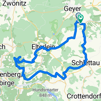
Tannenberg-Stauweiher
A cycling route starting in Tannenberg, Saxony, Germany.
Overview
About this route
Abendrunde von Tannenberg nach Geyer zum Stauweiher und wieder zurück.
- -:--
- Duration
- 13.6 km
- Distance
- 236 m
- Ascent
- 238 m
- Descent
- ---
- Avg. speed
- ---
- Max. altitude

Route quality
Waytypes & surfaces along the route
Waytypes
Track
7.1 km
(52 %)
Cycleway
1.2 km
(9 %)
Surfaces
Paved
8.3 km
(61 %)
Unpaved
4.3 km
(32 %)
Asphalt
6.2 km
(46 %)
Gravel
2 km
(15 %)
Continue with Bikemap
Use, edit, or download this cycling route
You would like to ride Tannenberg-Stauweiher or customize it for your own trip? Here is what you can do with this Bikemap route:
Free features
- Save this route as favorite or in collections
- Copy & plan your own version of this route
- Sync your route with Garmin or Wahoo
Premium features
Free trial for 3 days, or one-time payment. More about Bikemap Premium.
- Navigate this route on iOS & Android
- Export a GPX / KML file of this route
- Create your custom printout (try it for free)
- Download this route for offline navigation
Discover more Premium features.
Get Bikemap PremiumFrom our community
Other popular routes starting in Tannenberg
 Untere Dorfstraße nach Fichtelbergstraße
- Distance
- 28.3 km
- Ascent
- 943 m
- Descent
- 232 m
- Location
- Tannenberg, Saxony, Germany
 Logistik-Rück-6
- Distance
- 5.6 km
- Ascent
- 126 m
- Descent
- 208 m
- Location
- Tannenberg, Saxony, Germany
 Obere Dorfstraße nach Obere Dorfstraße
- Distance
- 38.4 km
- Ascent
- 797 m
- Descent
- 797 m
- Location
- Tannenberg, Saxony, Germany
 Sven's Hausrunde
- Distance
- 33.8 km
- Ascent
- 313 m
- Descent
- 313 m
- Location
- Tannenberg, Saxony, Germany
 Untere Dorfstraße 58, Tannenberg nach Zu den Schanzen 1, Geyer
- Distance
- 3.8 km
- Ascent
- 79 m
- Descent
- 37 m
- Location
- Tannenberg, Saxony, Germany
 Tannenberg > Königswalde
- Distance
- 18.7 km
- Ascent
- 277 m
- Descent
- 273 m
- Location
- Tannenberg, Saxony, Germany
 Obere Dorfstraße nach Obere Dorfstraße
- Distance
- 37.2 km
- Ascent
- 786 m
- Descent
- 783 m
- Location
- Tannenberg, Saxony, Germany
 Obere Dorfstraße nach Obere Dorfstraße
- Distance
- 25.9 km
- Ascent
- 463 m
- Descent
- 462 m
- Location
- Tannenberg, Saxony, Germany
Open it in the app