

Kinderdijk Windmills
A cycling route starting in Ridderkerk, South Holland, The Netherlands.
Overview
About this route
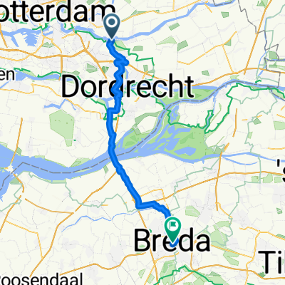
Kinderdijk Cycle Route Start - 3 - *** - 76 - 37 - 10 - 66 - 67 - *** - 5 - 7 - 19 - 2 - 3 - Finish
Start: At the ferry you follow the numbered cycle network to 3. ***: From 3 you follow the dyke all the way to the ferry at Bergstoep. Here you pick up the numbered cycle network to 76.
***: From 67 you head towards 6 until you get to the Ammersekade. Here you turn left and at the bottom of the dyke directly right (Boven Tiendweg). Follow this cycle path until you get to 5. Here you pick up the numbered cycle network. Finish: The route takes you back to the ferry at Kinderdijk.
- -:--
- Duration
- 43.2 km
- Distance
- 13 m
- Ascent
- 13 m
- Descent
- ---
- Avg. speed
- ---
- Max. altitude
Route quality
Waytypes & surfaces along the route
Waytypes
Road
15.5 km
(36 %)
Cycleway
11.2 km
(26 %)
Surfaces
Paved
20.3 km
(47 %)
Unpaved
4.3 km
(10 %)
Asphalt
19.4 km
(45 %)
Loose gravel
4.3 km
(10 %)
Continue with Bikemap
Use, edit, or download this cycling route
You would like to ride Kinderdijk Windmills or customize it for your own trip? Here is what you can do with this Bikemap route:
Free features
- Save this route as favorite or in collections
- Copy & plan your own version of this route
- Sync your route with Garmin or Wahoo
Premium features
Free trial for 3 days, or one-time payment. More about Bikemap Premium.
- Navigate this route on iOS & Android
- Export a GPX / KML file of this route
- Create your custom printout (try it for free)
- Download this route for offline navigation
Discover more Premium features.
Get Bikemap PremiumFrom our community
Other popular routes starting in Ridderkerk
 31. Kinderdijk - Schoonhoven langs de molens
- Distance
- 48.6 km
- Ascent
- 4 m
- Descent
- 4 m
- Location
- Ridderkerk, South Holland, The Netherlands
 Kinderdijk Fun
- Distance
- 24.1 km
- Ascent
- 0 m
- Descent
- 4 m
- Location
- Ridderkerk, South Holland, The Netherlands
 Holland 2017 Day 3
- Distance
- 93.3 km
- Ascent
- 0 m
- Descent
- 0 m
- Location
- Ridderkerk, South Holland, The Netherlands
 havenstraat, ridderkerk
- Distance
- 41 km
- Ascent
- 44 m
- Descent
- 38 m
- Location
- Ridderkerk, South Holland, The Netherlands
 Willem Landréstraat 62, Ridderkerk naar Willem Landréstraat 36, Ridderkerk
- Distance
- 64.3 km
- Ascent
- 53 m
- Descent
- 65 m
- Location
- Ridderkerk, South Holland, The Netherlands
 Day 2 Part 2
- Distance
- 49.1 km
- Ascent
- 50 m
- Descent
- 45 m
- Location
- Ridderkerk, South Holland, The Netherlands
 Ridderkerk - Roubaix
- Distance
- 267.9 km
- Ascent
- 377 m
- Descent
- 349 m
- Location
- Ridderkerk, South Holland, The Netherlands
 RZH 01
- Distance
- 70.3 km
- Ascent
- 16 m
- Descent
- 13 m
- Location
- Ridderkerk, South Holland, The Netherlands
Open it in the app