

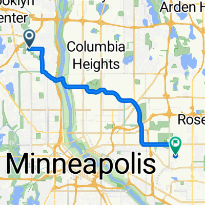
Victory Memorial Parkway (loads of Pokestops)
A cycling route starting in Robbinsdale, Minnesota, United States of America.
Overview
About this route
This route has massive amounts of stops.
- -:--
- Duration
- 8 km
- Distance
- 25 m
- Ascent
- 26 m
- Descent
- ---
- Avg. speed
- ---
- Avg. speed

Route quality
Waytypes & surfaces along the route
Waytypes
Cycleway
5.1 km
(63 %)
Road
2.1 km
(27 %)
Surfaces
Paved
6.7 km
(84 %)
Asphalt
5.3 km
(66 %)
Paved (undefined)
1.4 km
(18 %)
Undefined
1.3 km
(16 %)
Continue with Bikemap
Use, edit, or download this cycling route
You would like to ride Victory Memorial Parkway (loads of Pokestops) or customize it for your own trip? Here is what you can do with this Bikemap route:
Free features
- Save this route as favorite or in collections
- Copy & plan your own version of this route
- Sync your route with Garmin or Wahoo
Premium features
Free trial for 3 days, or one-time payment. More about Bikemap Premium.
- Navigate this route on iOS & Android
- Export a GPX / KML file of this route
- Create your custom printout (try it for free)
- Download this route for offline navigation
Discover more Premium features.
Get Bikemap PremiumFrom our community
Other popular routes starting in Robbinsdale
 B2B00380 55430 < 55108 via St. Anthony, Larpenteur
- Distance
- 16.3 km
- Ascent
- 81 m
- Descent
- 48 m
- Location
- Robbinsdale, Minnesota, United States of America
 B2B00476 55422>55425 via Irving Av, 2nd St, Portland Av, 12th Av S
- Distance
- 31.4 km
- Ascent
- 67 m
- Descent
- 86 m
- Location
- Robbinsdale, Minnesota, United States of America
 Levalos
- Distance
- 4.2 km
- Ascent
- 16 m
- Descent
- 12 m
- Location
- Robbinsdale, Minnesota, United States of America
 15m theo-cedar-west river
- Distance
- 23.9 km
- Ascent
- 118 m
- Descent
- 120 m
- Location
- Robbinsdale, Minnesota, United States of America
 sohochi park trl and Lee park
- Distance
- 7.7 km
- Ascent
- 114 m
- Descent
- 118 m
- Location
- Robbinsdale, Minnesota, United States of America
 11.5 marshall-stonearch-west river
- Distance
- 18.5 km
- Ascent
- 118 m
- Descent
- 121 m
- Location
- Robbinsdale, Minnesota, United States of America
 25 Mile Loop
- Distance
- 40.4 km
- Ascent
- 185 m
- Descent
- 185 m
- Location
- Robbinsdale, Minnesota, United States of America
 B2B00437 55429>55402 via 42 Av N, 2nd St, Hennepin Av
- Distance
- 13.4 km
- Ascent
- 21 m
- Descent
- 24 m
- Location
- Robbinsdale, Minnesota, United States of America
Open it in the app