

Am Müggelsee
A cycling route starting in Köpenick, State of Berlin, Germany.
Overview
About this route
Müggelsee is not only Berlin's largest lake, but it is also a playground for water sports enthusiasts. Beautifully situated in the district of Treptow-Köpenick, it also attracts bathers and leisure cyclists who, in nice weather, ensure lively traffic on the shore paths.
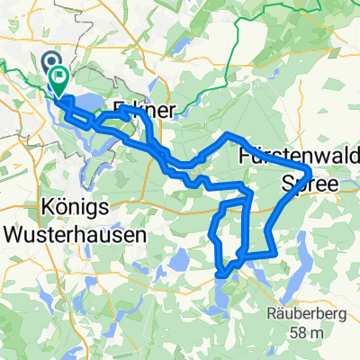
We start our tour at the bronze sculpture 'Father, Mother and Child' by Hans-Detlev Henning, located directly in front of the Spindlersfeld S-Bahn station. From Ernst-Grube-Straße, we turn left into Oberspreestraße, cross the long bridge over the Dahme, and can already plan a first stop at Köpenick Castle.
Since 2004, the Museum of Decorative Arts of the State Museums of Berlin has been housed here next to its main office at the Kulturforum.
We now follow Müggelheimer Straße until we reach Wendenschloßstraße, where we turn left and continue to Salvador-Allende-Straße. Here, again to the left and a few meters further, just before the bridge, we turn right down the street toward the Spree. This section is called 'Müggelspree' because the river finds its way through Müggelsee. Before the lake, however, there is still the Spree-Arche, a restaurant ship in the middle of the water and the Spree tunnel, through which you can reach Friedrichshagen (with the beautiful Bölschestraße).
However, we stay on the right bank and now cycle along the shore of Müggelsee. Anyone needing refreshment or a snack stops at the Inn 'Rübezahl' or cycles further to the 'Little Müggelsee'. On the marked cycling path R1, we now take the route through Müggelheimer Forest to the Old Spree Arm. There, a small wooden bridge (Russenbrücke) leads into Hessewinkel and continues over Triglawstraße, Im Hasenwinkel, Biberpelzstraße and Rialtoring to 'New Venice'.
The residential and weekend house settlement in the Berlin district of Rahnsdorf (Wilhelmshagen) is idyllically located in a river delta, with many canals and arms of the Spree. Most plots in this area are water properties, many of which have a dock or boathouse.
At Fürstenwalder Allee, we turn right and then left onto Schönblicker Straße until we reach the Wilhelmshagen S-Bahn station. There ends the approximately 20-kilometer 'Lake Tour'. Text and photos: Klaus Tolkmitt.
- -:--
- Duration
- 19.6 km
- Distance
- 66 m
- Ascent
- 58 m
- Descent
- ---
- Avg. speed
- ---
- Max. altitude

Route photos


Continue with Bikemap
Use, edit, or download this cycling route
You would like to ride Am Müggelsee or customize it for your own trip? Here is what you can do with this Bikemap route:
Free features
- Save this route as favorite or in collections
- Copy & plan your own version of this route
- Sync your route with Garmin or Wahoo
Premium features
Free trial for 3 days, or one-time payment. More about Bikemap Premium.
- Navigate this route on iOS & Android
- Export a GPX / KML file of this route
- Create your custom printout (try it for free)
- Download this route for offline navigation
Discover more Premium features.
Get Bikemap PremiumFrom our community
Other popular routes starting in Köpenick
 Rund um das Löcknitztal
- Distance
- 94.9 km
- Ascent
- 231 m
- Descent
- 229 m
- Location
- Köpenick, State of Berlin, Germany
 Ersatzrunde für Rund um den Scharmützelsee
- Distance
- 134.6 km
- Ascent
- 353 m
- Descent
- 349 m
- Location
- Köpenick, State of Berlin, Germany
 Carl-Spindler-Straße 13, Berlin nach Carl-Spindler-Straße 11, Berlin
- Distance
- 47.5 km
- Ascent
- 123 m
- Descent
- 128 m
- Location
- Köpenick, State of Berlin, Germany
 Ost- und Randberliner Wasser-Tour
- Distance
- 62.9 km
- Ascent
- 89 m
- Descent
- 91 m
- Location
- Köpenick, State of Berlin, Germany
 th299 Köpenick-Wuhle-Börnicke-Bernau
- Distance
- 45.8 km
- Ascent
- 244 m
- Descent
- 209 m
- Location
- Köpenick, State of Berlin, Germany
 Vom Bahnhof Köpenick zum Bhf. Hirschgarten
- Distance
- 10 km
- Ascent
- 24 m
- Descent
- 25 m
- Location
- Köpenick, State of Berlin, Germany
 Dahme Radweg2
- Distance
- 89.6 km
- Ascent
- 129 m
- Descent
- 100 m
- Location
- Köpenick, State of Berlin, Germany
 Teltowkanal-Treptow-Köpenick Rundfahrt
- Distance
- 31.3 km
- Ascent
- 26 m
- Descent
- 26 m
- Location
- Köpenick, State of Berlin, Germany
Open it in the app