

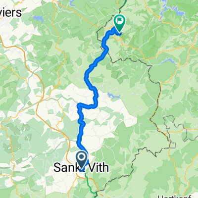
L46 (3101) Steinebrück - Pronsfeld
A cycling route starting in Sankt Vith, Wallonia, Belgium.
Overview
About this route
PréRAVeL Steinebrück - Bleialf - Pronsfeld
- -:--
- Duration
- 18.2 km
- Distance
- 154 m
- Ascent
- 161 m
- Descent
- ---
- Avg. speed
- 497 m
- Max. altitude

Route quality
Waytypes & surfaces along the route
Waytypes
Cycleway
7.4 km
(41 %)
Track
7.3 km
(40 %)
Surfaces
Paved
17.4 km
(96 %)
Asphalt
16.7 km
(92 %)
Paved (undefined)
0.7 km
(4 %)
Undefined
0.7 km
(4 %)
Route highlights
Points of interest along the route
 Steinebrück - Pronsfeld\"")
Point of interest after 8 km
Tunnel Bleialf
 Steinebrück - Pronsfeld\"")
Photo after 18.2 km
Bahnhof Pronsfeld
Continue with Bikemap
Use, edit, or download this cycling route
You would like to ride L46 (3101) Steinebrück - Pronsfeld or customize it for your own trip? Here is what you can do with this Bikemap route:
Free features
- Save this route as favorite or in collections
- Copy & plan your own version of this route
- Sync your route with Garmin or Wahoo
Premium features
Free trial for 3 days, or one-time payment. More about Bikemap Premium.
- Navigate this route on iOS & Android
- Export a GPX / KML file of this route
- Create your custom printout (try it for free)
- Download this route for offline navigation
Discover more Premium features.
Get Bikemap PremiumFrom our community
Other popular routes starting in Sankt Vith
 TW-Etape 5 Saint-Vith - Eupen
- Distance
- 53.1 km
- Ascent
- 401 m
- Descent
- 517 m
- Location
- Sankt Vith, Wallonia, Belgium
 75 Km_3LF_2010
- Distance
- 75.5 km
- Ascent
- 967 m
- Descent
- 969 m
- Location
- Sankt Vith, Wallonia, Belgium
 150 Km_3LF_2010
- Distance
- 148.6 km
- Ascent
- 2,015 m
- Descent
- 2,002 m
- Location
- Sankt Vith, Wallonia, Belgium
 Vennbahn: Day 2 - Saint Vith to Monschau
- Distance
- 46.5 km
- Ascent
- 417 m
- Descent
- 485 m
- Location
- Sankt Vith, Wallonia, Belgium
 Route to Wasserbillig
- Distance
- 105.6 km
- Ascent
- 1,583 m
- Descent
- 1,917 m
- Location
- Sankt Vith, Wallonia, Belgium
 L46 (3101) Steinebrück - Pronsfeld
- Distance
- 18.2 km
- Ascent
- 154 m
- Descent
- 161 m
- Location
- Sankt Vith, Wallonia, Belgium
 Vielsalm - Beho - Maldingen - Crombach - Rodt - Skihütte
- Distance
- 44.4 km
- Ascent
- 399 m
- Descent
- 399 m
- Location
- Sankt Vith, Wallonia, Belgium
 Přejezd Německa 23.7.2016
- Distance
- 99.6 km
- Ascent
- 764 m
- Descent
- 780 m
- Location
- Sankt Vith, Wallonia, Belgium
Open it in the app