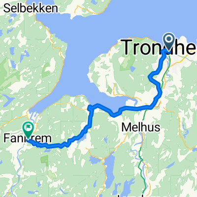
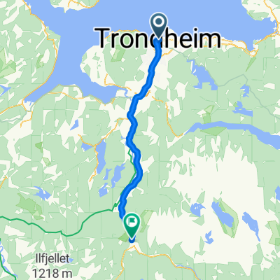
Trodheim 1.8.16
A cycling route starting in Trondheim, Sør-Trøndelag Fylke, Norway.
Overview
About this route
- -:--
- Duration
- 79.4 km
- Distance
- 0 m
- Ascent
- 0 m
- Descent
- ---
- Avg. speed
- ---
- Max. altitude
Route quality
Waytypes & surfaces along the route
Waytypes
Cycleway
22.2 km
(28 %)
Quiet road
3.2 km
(4 %)
Surfaces
Paved
55.6 km
(70 %)
Unpaved
16.7 km
(21 %)
Asphalt
55.6 km
(70 %)
Gravel
15.9 km
(20 %)
Continue with Bikemap
Use, edit, or download this cycling route
You would like to ride Trodheim 1.8.16 or customize it for your own trip? Here is what you can do with this Bikemap route:
Free features
- Save this route as favorite or in collections
- Copy & plan your own version of this route
- Sync your route with Garmin or Wahoo
Premium features
Free trial for 3 days, or one-time payment. More about Bikemap Premium.
- Navigate this route on iOS & Android
- Export a GPX / KML file of this route
- Create your custom printout (try it for free)
- Download this route for offline navigation
Discover more Premium features.
Get Bikemap PremiumFrom our community
Other popular routes starting in Trondheim
- Storfossen waterfall
- Distance
- 18.1 km
- Ascent
- 276 m
- Descent
- 262 m
- Location
- Trondheim, Sør-Trøndelag Fylke, Norway
- Jonsvannet 30 km
- Distance
- 30.9 km
- Ascent
- 0 m
- Descent
- 0 m
- Location
- Trondheim, Sør-Trøndelag Fylke, Norway
- trondheim tri
- Distance
- 48.9 km
- Ascent
- 652 m
- Descent
- 652 m
- Location
- Trondheim, Sør-Trøndelag Fylke, Norway
- 75. Trondheim to KyrksÌterøra
- Distance
- 100.8 km
- Ascent
- 1,764 m
- Descent
- 1,758 m
- Location
- Trondheim, Sør-Trøndelag Fylke, Norway
- Byneset via ByĂĽasen
- Distance
- 41.8 km
- Ascent
- 506 m
- Descent
- 513 m
- Location
- Trondheim, Sør-Trøndelag Fylke, Norway
- Hommelvik - Jonsvatnet rundt
- Distance
- 66 km
- Ascent
- 503 m
- Descent
- 535 m
- Location
- Trondheim, Sør-Trøndelag Fylke, Norway
- Norskekysten sør til nord etappe 4.1 19/7: Trondheim - Langnesodden Camping,
- Distance
- 105.2 km
- Ascent
- 839 m
- Descent
- 813 m
- Location
- Trondheim, Sør-Trøndelag Fylke, Norway
- SĂźdroute
- Distance
- 85.1 km
- Ascent
- 1,086 m
- Descent
- 1,147 m
- Location
- Trondheim, Sør-Trøndelag Fylke, Norway
Open it in the app