

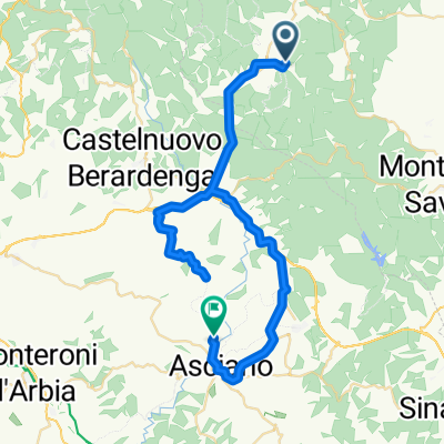
Ambra - Poggio all'Olma - Cennina
A cycling route starting in Ambra, Tuscany, Italy.
Overview
About this route
Schöner Freeride / Single Trail von Poggio All' Olma nach Ambra.
- -:--
- Duration
- 21.8 km
- Distance
- 572 m
- Ascent
- 572 m
- Descent
- ---
- Avg. speed
- ---
- Max. altitude
Route quality
Waytypes & surfaces along the route
Waytypes
Track
8.4 km
(39 %)
Quiet road
5 km
(23 %)
Surfaces
Paved
6.9 km
(32 %)
Unpaved
9.9 km
(45 %)
Ground
4.7 km
(21 %)
Paved (undefined)
3.8 km
(17 %)
Continue with Bikemap
Use, edit, or download this cycling route
You would like to ride Ambra - Poggio all'Olma - Cennina or customize it for your own trip? Here is what you can do with this Bikemap route:
Free features
- Save this route as favorite or in collections
- Copy & plan your own version of this route
- Sync your route with Garmin or Wahoo
Premium features
Free trial for 3 days, or one-time payment. More about Bikemap Premium.
- Navigate this route on iOS & Android
- Export a GPX / KML file of this route
- Create your custom printout (try it for free)
- Download this route for offline navigation
Discover more Premium features.
Get Bikemap PremiumFrom our community
Other popular routes starting in Ambra
 Badia a Ruoti-Berardenga-Rosennano-zurück
- Distance
- 36.3 km
- Ascent
- 752 m
- Descent
- 736 m
- Location
- Ambra, Tuscany, Italy
 Cennina 88km/1'020hm
- Distance
- 86.9 km
- Ascent
- 736 m
- Descent
- 740 m
- Location
- Ambra, Tuscany, Italy
 Badia-Asciano-Badia
- Distance
- 51.8 km
- Ascent
- 748 m
- Descent
- 790 m
- Location
- Ambra, Tuscany, Italy
 Cennina 42km/1030hm
- Distance
- 42.2 km
- Ascent
- 927 m
- Descent
- 928 m
- Location
- Ambra, Tuscany, Italy
 Ambra - Monte Luca - Cennina
- Distance
- 30.4 km
- Ascent
- 606 m
- Descent
- 613 m
- Location
- Ambra, Tuscany, Italy
 Ambra - Poggio all'Olma - Cennina
- Distance
- 21.8 km
- Ascent
- 572 m
- Descent
- 572 m
- Location
- Ambra, Tuscany, Italy
 Cennina 82km/1370hm
- Distance
- 82.1 km
- Ascent
- 1,058 m
- Descent
- 1,059 m
- Location
- Ambra, Tuscany, Italy
 Cennina 90km/890hm
- Distance
- 90.7 km
- Ascent
- 538 m
- Descent
- 539 m
- Location
- Ambra, Tuscany, Italy
Open it in the app