
Overview
About this route
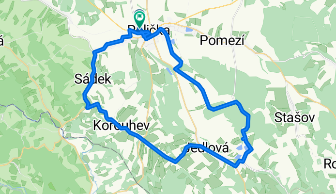
Pohodový výlet na Baldu a Jedlovské rybníky.
- -:--
- Duration
- 30.5 km
- Distance
- 219 m
- Ascent
- 214 m
- Descent
- ---
- Avg. speed
- ---
- Max. altitude

Part of
Výlety na kole 2016
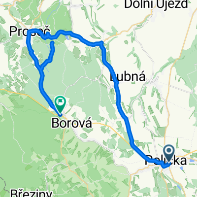
2 stages
Route quality
Waytypes & surfaces along the route
Waytypes
Road
14.6 km
(48 %)
Quiet road
3.1 km
(10 %)
Surfaces
Paved
3.1 km
(10 %)
Unpaved
2.1 km
(7 %)
Asphalt
2.1 km
(7 %)
Gravel
1.8 km
(6 %)
Continue with Bikemap
Use, edit, or download this cycling route
You would like to ride Balda-Kaple 2016 or customize it for your own trip? Here is what you can do with this Bikemap route:
Free features
- Save this route as favorite or in collections
- Copy & plan your own version of this route
- Sync your route with Garmin or Wahoo
Premium features
Free trial for 3 days, or one-time payment. More about Bikemap Premium.
- Navigate this route on iOS & Android
- Export a GPX / KML file of this route
- Create your custom printout (try it for free)
- Download this route for offline navigation
Discover more Premium features.
Get Bikemap PremiumFrom our community
Other popular routes starting in Polička
 Výlet po okolí
- Distance
- 55.7 km
- Ascent
- 863 m
- Descent
- 828 m
- Location
- Polička, Pardubický kraj, Czechia
 Balda-Kaple 2016
- Distance
- 30.5 km
- Ascent
- 219 m
- Descent
- 214 m
- Location
- Polička, Pardubický kraj, Czechia
 Budislav
- Distance
- 32 km
- Ascent
- 536 m
- Descent
- 448 m
- Location
- Polička, Pardubický kraj, Czechia
 Suchý Vrch
- Distance
- 134.2 km
- Ascent
- 1,908 m
- Descent
- 1,908 m
- Location
- Polička, Pardubický kraj, Czechia
 Rozjíždkové trasy 2016
- Distance
- 177.7 km
- Ascent
- 1,058 m
- Descent
- 1,060 m
- Location
- Polička, Pardubický kraj, Czechia
 Milovy
- Distance
- 44.4 km
- Ascent
- 470 m
- Descent
- 470 m
- Location
- Polička, Pardubický kraj, Czechia
 Polička - Tišnov přes hrad Svojanov
- Distance
- 60.5 km
- Ascent
- 1,006 m
- Descent
- 1,228 m
- Location
- Polička, Pardubický kraj, Czechia
 Polička - Bystřice nad Pernštejnem, pěšky
- Distance
- 31.4 km
- Ascent
- 564 m
- Descent
- 552 m
- Location
- Polička, Pardubický kraj, Czechia
Open it in the app