
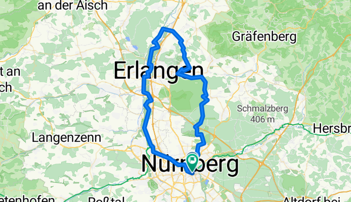
Nbg (Hbf) - Beiersdorf - Erlangen - Fürth - Nbg (Hbf)
A cycling route starting in Nuremberg, Bavaria, Germany.
Overview
About this route
Rundtour von Nbg über Buchenbühl (z. T. auf dem Burgenradweg), Buckenhof und Uttenreuth (Erlangen), Marloffstein, Adlitz nach Beiersdorf - auf dem Regnitzradweg o. Kanalroute nach Erlangen und Fürth - auf Pegnitzradweg zurück nach Nbg
- -:--
- Duration
- 74.7 km
- Distance
- 269 m
- Ascent
- 271 m
- Descent
- ---
- Avg. speed
- ---
- Max. altitude

Route quality
Waytypes & surfaces along the route
Waytypes
Track
31.4 km
(42 %)
Path
21.7 km
(29 %)
Surfaces
Paved
44.8 km
(60 %)
Unpaved
25.4 km
(34 %)
Asphalt
41.9 km
(56 %)
Gravel
23.2 km
(31 %)
Route highlights
Points of interest along the route
Point of interest after 17.9 km
Dürrer Quelle
Point of interest after 18.5 km
Tropfender Fels
Point of interest after 24.4 km
Schlucht der fünf Schützen
Continue with Bikemap
Use, edit, or download this cycling route
You would like to ride Nbg (Hbf) - Beiersdorf - Erlangen - Fürth - Nbg (Hbf) or customize it for your own trip? Here is what you can do with this Bikemap route:
Free features
- Save this route as favorite or in collections
- Copy & plan your own version of this route
- Sync your route with Garmin or Wahoo
Premium features
Free trial for 3 days, or one-time payment. More about Bikemap Premium.
- Navigate this route on iOS & Android
- Export a GPX / KML file of this route
- Create your custom printout (try it for free)
- Download this route for offline navigation
Discover more Premium features.
Get Bikemap PremiumFrom our community
Other popular routes starting in Nuremberg
 Feierabendtour ins Nürnberger Umland
- Distance
- 34.8 km
- Ascent
- 191 m
- Descent
- 190 m
- Location
- Nuremberg, Bavaria, Germany
 D_Bayern_Nürnberg-Entenberg-Happurger Stausee: 4 Berge Tour
- Distance
- 82.2 km
- Ascent
- 1,093 m
- Descent
- 1,051 m
- Location
- Nuremberg, Bavaria, Germany
 Nbg-Waller-Nbg
- Distance
- 106.8 km
- Ascent
- 451 m
- Descent
- 451 m
- Location
- Nuremberg, Bavaria, Germany
 Nürnberg - 5 Flüsse Radweg (Runde) ,300km, 2011-05-19...22
- Distance
- 288.5 km
- Ascent
- 0 m
- Descent
- 0 m
- Location
- Nuremberg, Bavaria, Germany
 MTB über Moritzberg, Reuther Berg und Brunner berg
- Distance
- 48.5 km
- Ascent
- 413 m
- Descent
- 412 m
- Location
- Nuremberg, Bavaria, Germany
 Nürnberg Süd -Ost
- Distance
- 57.2 km
- Ascent
- 325 m
- Descent
- 322 m
- Location
- Nuremberg, Bavaria, Germany
 1.runde
- Distance
- 62.5 km
- Ascent
- 256 m
- Descent
- 256 m
- Location
- Nuremberg, Bavaria, Germany
 D_Bayern_Nürnberg-Pottenstein-Gößweinstein-Wohlmannsgesees-Leutenbach: "Tour der 1000 Hügel"
- Distance
- 130.6 km
- Ascent
- 1,754 m
- Descent
- 1,741 m
- Location
- Nuremberg, Bavaria, Germany
Open it in the app