

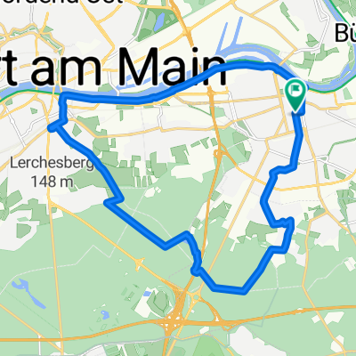
Einmal Stadtteil-Fechenheim nach Stadtteil-Höchst und zurück nach Fechenheim
A cycling route starting in Offenbach, Hesse, Germany.
Overview
About this route
From Dieselstraße stop, follow line 11 to Höchst, preferably on the bike path......
In Höchst then to the Leuna Bridge, cross the Main there and along the southern bank, head back towards Fechenheim........
- -:--
- Duration
- 40.7 km
- Distance
- 49 m
- Ascent
- 49 m
- Descent
- ---
- Avg. speed
- ---
- Max. altitude

Route quality
Waytypes & surfaces along the route
Waytypes
Path
20.3 km
(50 %)
Quiet road
6.1 km
(15 %)
Surfaces
Paved
29.3 km
(72 %)
Unpaved
1.2 km
(3 %)
Asphalt
26.4 km
(65 %)
Paved (undefined)
2.4 km
(6 %)
Continue with Bikemap
Use, edit, or download this cycling route
You would like to ride Einmal Stadtteil-Fechenheim nach Stadtteil-Höchst und zurück nach Fechenheim or customize it for your own trip? Here is what you can do with this Bikemap route:
Free features
- Save this route as favorite or in collections
- Copy & plan your own version of this route
- Sync your route with Garmin or Wahoo
Premium features
Free trial for 3 days, or one-time payment. More about Bikemap Premium.
- Navigate this route on iOS & Android
- Export a GPX / KML file of this route
- Create your custom printout (try it for free)
- Download this route for offline navigation
Discover more Premium features.
Get Bikemap PremiumFrom our community
Other popular routes starting in Offenbach
 Goetheturmfahrt
- Distance
- 18.5 km
- Ascent
- 85 m
- Descent
- 92 m
- Location
- Offenbach, Hesse, Germany
 Wetterau Rennrad
- Distance
- 48.3 km
- Ascent
- 175 m
- Descent
- 175 m
- Location
- Offenbach, Hesse, Germany
 08 - Maintal Schlösser und Parks
- Distance
- 24.7 km
- Ascent
- 66 m
- Descent
- 64 m
- Location
- Offenbach, Hesse, Germany
 Nidda Tour Stockhausen
- Distance
- 83.3 km
- Ascent
- 555 m
- Descent
- 379 m
- Location
- Offenbach, Hesse, Germany
 OF-Götzemhain-Dietzenbach-Rodgau-OF
- Distance
- 37.4 km
- Ascent
- 123 m
- Descent
- 110 m
- Location
- Offenbach, Hesse, Germany
 Einmal Airport und zurück
- Distance
- 62.1 km
- Ascent
- 104 m
- Descent
- 103 m
- Location
- Offenbach, Hesse, Germany
 Rhein-Main-Runde
- Distance
- 158.2 km
- Ascent
- 522 m
- Descent
- 521 m
- Location
- Offenbach, Hesse, Germany
 Hausrunde
- Distance
- 65.1 km
- Ascent
- 364 m
- Descent
- 348 m
- Location
- Offenbach, Hesse, Germany
Open it in the app