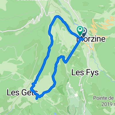
Day 1
A cycling route starting in Morzine, Auvergne-Rh么ne-Alpes, France.
Overview
About this route
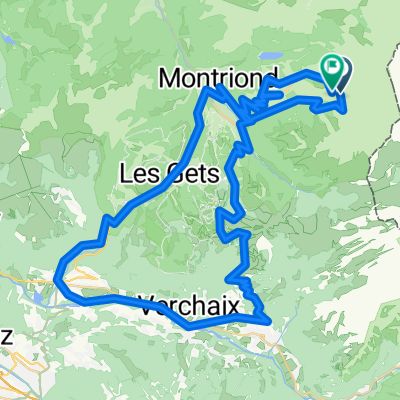
Encrenaz, Ramaz, Rochetaillee (Grand Taillet), Corbier, Joux Verte
Options to cut: Joux Verte (-1000m, -30km) and Rochetaillee (-400m, -14km)
Options to add: Avernaz and Terramont聽
聽
- -:--
- Duration
- 137.6 km
- Distance
- 3,476 m
- Ascent
- 3,461 m
- Descent
- ---
- Avg. speed
- ---
- Avg. speed
Route quality
Waytypes & surfaces along the route
Waytypes
Road
95.7 km
(70 %)
Busy road
21.8 km
(16 %)
Surfaces
Paved
98.6 km
(72 %)
Unpaved
3.9 km
(3 %)
Asphalt
93.6 km
(68 %)
Concrete
5 km
(4 %)
Continue with Bikemap
Use, edit, or download this cycling route
You would like to ride Day 1 or customize it for your own trip? Here is what you can do with this Bikemap route:
Free features
- Save this route as favorite or in collections
- Copy & plan your own version of this route
- Split it into stages to create a multi-day tour
- Sync your route with Garmin or Wahoo
Premium features
Free trial for 3 days, or one-time payment. More about Bikemap Premium.
- Navigate this route on iOS & Android
- Export a GPX / KML file of this route
- Create your custom printout (try it for free)
- Download this route for offline navigation
Discover more Premium features.
Get Bikemap PremiumFrom our community
Other popular routes starting in Morzine
- Tour d'Enfer : Day 1 - Morzine to La Clusaz
- Distance
- 75.7 km
- Ascent
- 1,814 m
- Descent
- 1,629 m
- Location
- Morzine, Auvergne-Rh么ne-Alpes, France
- Morzine - Col de la Ramaz - Col de la Colombi猫re
- Distance
- 133.7 km
- Ascent
- 2,660 m
- Descent
- 2,654 m
- Location
- Morzine, Auvergne-Rh么ne-Alpes, France
- Morzine - Col de la Joux Verte
- Distance
- 30.3 km
- Ascent
- 861 m
- Descent
- 861 m
- Location
- Morzine, Auvergne-Rh么ne-Alpes, France
- Alps Three Peaks Challenge Col de Joux Verte, Col de Jeu Plane, Col de l'Encrenaz
- Distance
- 76 km
- Ascent
- 2,340 m
- Descent
- 2,347 m
- Location
- Morzine, Auvergne-Rh么ne-Alpes, France
- Tour of Le Roc d'Enfer Alps Challenge Route
- Distance
- 109.8 km
- Ascent
- 1,883 m
- Descent
- 1,883 m
- Location
- Morzine, Auvergne-Rh么ne-Alpes, France
- Morzine-Avoriaz
- Distance
- 29.2 km
- Ascent
- 922 m
- Descent
- 906 m
- Location
- Morzine, Auvergne-Rh么ne-Alpes, France
- Tour du Roc d'Enfer
- Distance
- 78.9 km
- Ascent
- 1,128 m
- Descent
- 1,121 m
- Location
- Morzine, Auvergne-Rh么ne-Alpes, France
- Morzine Sportive - Short Version
- Distance
- 103.6 km
- Ascent
- 1,763 m
- Descent
- 1,761 m
- Location
- Morzine, Auvergne-Rh么ne-Alpes, France
Open it in the app