Vogezen 2016 83k 2300hm zuid (Le Thillot)
A cycling route starting in Le Thillot, Alsace-Champagne-Ardenne-Lorraine, France.
Overview
About this route
Vanuit Le Thillot, Ballon de Servance, Planche des Belles Filles, vloevlievla, Le Thillot
- -:--
- Duration
- 83.1 km
- Distance
- 2,130 m
- Ascent
- 2,130 m
- Descent
- ---
- Avg. speed
- ---
- Avg. speed
Route quality
Waytypes & surfaces along the route
Waytypes
Quiet road
37.2 km
(45 %)
Road
32 km
(39 %)
Surfaces
Paved
15.6 km
(19 %)
Asphalt
15.6 km
(19 %)
Undefined
67.5 km
(81 %)
Continue with Bikemap
Use, edit, or download this cycling route
You would like to ride Vogezen 2016 83k 2300hm zuid (Le Thillot) or customize it for your own trip? Here is what you can do with this Bikemap route:
Free features
- Save this route as favorite or in collections
- Copy & plan your own version of this route
- Sync your route with Garmin or Wahoo
Premium features
Free trial for 3 days, or one-time payment. More about Bikemap Premium.
- Navigate this route on iOS & Android
- Export a GPX / KML file of this route
- Create your custom printout (try it for free)
- Download this route for offline navigation
Discover more Premium features.
Get Bikemap PremiumFrom our community
Other popular routes starting in Le Thillot
- Col du Ballon de Servance - La Planche des belles filles - Col du Ballon d'Alsace
- Distance
- 2,277.8 km
- Ascent
- 494,572 m
- Descent
- 494,572 m
- Location
- Le Thillot, Alsace-Champagne-Ardenne-Lorraine, France
- Rondje Grand Ballon (97km)
- Distance
- 97.4 km
- Ascent
- 1,617 m
- Descent
- 1,617 m
- Location
- Le Thillot, Alsace-Champagne-Ardenne-Lorraine, France
- Col des Croix - Col de Chevrères - Ballon de Servance
- Distance
- 58 km
- Ascent
- 1,351 m
- Descent
- 1,351 m
- Location
- Le Thillot, Alsace-Champagne-Ardenne-Lorraine, France
- Le Thillot - La Bresse
- Distance
- 28.9 km
- Ascent
- 1,227 m
- Descent
- 986 m
- Location
- Le Thillot, Alsace-Champagne-Ardenne-Lorraine, France
- Anfahrt Planche des Belles Filles
- Distance
- 26.4 km
- Ascent
- 991 m
- Descent
- 635 m
- Location
- Le Thillot, Alsace-Champagne-Ardenne-Lorraine, France
- Tour de France Route part 2
- Distance
- 11.6 km
- Ascent
- 212 m
- Descent
- 261 m
- Location
- Le Thillot, Alsace-Champagne-Ardenne-Lorraine, France
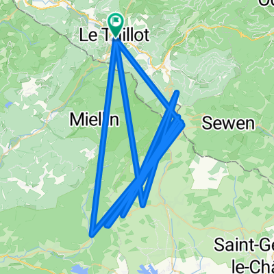
- Le Thillot - Voie verte
- Distance
- 52.1 km
- Ascent
- 273 m
- Descent
- 276 m
- Location
- Le Thillot, Alsace-Champagne-Ardenne-Lorraine, France
- Vogezen 2016 83k 2300hm zuid (Le Thillot)
- Distance
- 83.1 km
- Ascent
- 2,130 m
- Descent
- 2,130 m
- Location
- Le Thillot, Alsace-Champagne-Ardenne-Lorraine, France
Open it in the app