

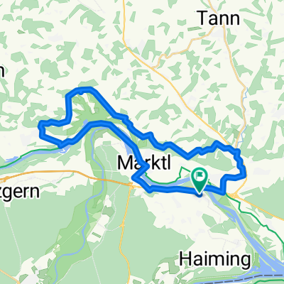
Bruckmühl Burghausen Altötting und zurück
A cycling route starting in Stammham, Bavaria, Germany.
Overview
About this route
- -:--
- Duration
- 46.2 km
- Distance
- 172 m
- Ascent
- 173 m
- Descent
- ---
- Avg. speed
- ---
- Max. altitude

Route quality
Waytypes & surfaces along the route
Waytypes
Cycleway
12.9 km
(28 %)
Quiet road
12.5 km
(27 %)
Surfaces
Paved
40.2 km
(87 %)
Unpaved
1.4 km
(3 %)
Asphalt
39.8 km
(86 %)
Gravel
1.4 km
(3 %)
Continue with Bikemap
Use, edit, or download this cycling route
You would like to ride Bruckmühl Burghausen Altötting und zurück or customize it for your own trip? Here is what you can do with this Bikemap route:
Free features
- Save this route as favorite or in collections
- Copy & plan your own version of this route
- Sync your route with Garmin or Wahoo
Premium features
Free trial for 3 days, or one-time payment. More about Bikemap Premium.
- Navigate this route on iOS & Android
- Export a GPX / KML file of this route
- Create your custom printout (try it for free)
- Download this route for offline navigation
Discover more Premium features.
Get Bikemap PremiumFrom our community
Other popular routes starting in Stammham
 Türkenbach-Holzlandrunde
- Distance
- 61.2 km
- Ascent
- 511 m
- Descent
- 511 m
- Location
- Stammham, Bavaria, Germany
 Innleitn-Runde
- Distance
- 43.4 km
- Ascent
- 441 m
- Descent
- 441 m
- Location
- Stammham, Bavaria, Germany
 Bruckmühl Burghausen Altötting und zurück
- Distance
- 46.2 km
- Ascent
- 172 m
- Descent
- 173 m
- Location
- Stammham, Bavaria, Germany
 Niedergottsauer Innleiten-Runde (Untertürken-Perach)
- Distance
- 29.8 km
- Ascent
- 265 m
- Descent
- 268 m
- Location
- Stammham, Bavaria, Germany
 Unteres-Alztal-Runde
- Distance
- 62.1 km
- Ascent
- 289 m
- Descent
- 290 m
- Location
- Stammham, Bavaria, Germany
 Dultmaßrunde Mühldorf 2014
- Distance
- 88.7 km
- Ascent
- 341 m
- Descent
- 341 m
- Location
- Stammham, Bavaria, Germany
 RC RITZLFUCHSER: Tourenradler Saisonfinale 01.10.16
- Distance
- 43.3 km
- Ascent
- 217 m
- Descent
- 217 m
- Location
- Stammham, Bavaria, Germany
 erweiterte Innspitzrunde
- Distance
- 82.5 km
- Ascent
- 418 m
- Descent
- 417 m
- Location
- Stammham, Bavaria, Germany
Open it in the app