

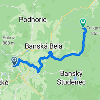
Krizny Buk Juh
A cycling route starting in Banská Štiavnica, Banská Bystrica Region, Slovakia.
Overview
About this route
BS-Drženice-Tlmače-Brehy-Krížny Buk-Pukanec Majer-BS
- -:--
- Duration
- 98.7 km
- Distance
- 1,082 m
- Ascent
- 1,082 m
- Descent
- ---
- Avg. speed
- ---
- Max. altitude
Route quality
Waytypes & surfaces along the route
Waytypes
Busy road
60.2 km
(61 %)
Road
17.7 km
(18 %)
Surfaces
Paved
78.5 km
(80 %)
Unpaved
2.1 km
(2 %)
Asphalt
77.8 km
(79 %)
Ground
1.7 km
(2 %)
Continue with Bikemap
Use, edit, or download this cycling route
You would like to ride Krizny Buk Juh or customize it for your own trip? Here is what you can do with this Bikemap route:
Free features
- Save this route as favorite or in collections
- Copy & plan your own version of this route
- Split it into stages to create a multi-day tour
- Sync your route with Garmin or Wahoo
Premium features
Free trial for 3 days, or one-time payment. More about Bikemap Premium.
- Navigate this route on iOS & Android
- Export a GPX / KML file of this route
- Create your custom printout (try it for free)
- Download this route for offline navigation
Discover more Premium features.
Get Bikemap PremiumFrom our community
Other popular routes starting in Banská Štiavnica
 Počúvadlianské jazero - Sitno - Vlčia jama - Križna - Evičkino jazero - Klinger - Banská Štiavnica
- Distance
- 16.8 km
- Ascent
- 544 m
- Descent
- 645 m
- Location
- Banská Štiavnica, Banská Bystrica Region, Slovakia
 Banská Belá do Banská Belá
- Distance
- 18 km
- Ascent
- 398 m
- Descent
- 386 m
- Location
- Banská Štiavnica, Banská Bystrica Region, Slovakia
 Recording from 22. 7. 2017, 17:15
- Distance
- 47.4 km
- Ascent
- 840 m
- Descent
- 840 m
- Location
- Banská Štiavnica, Banská Bystrica Region, Slovakia
 Okolo štiavnice
- Distance
- 51.7 km
- Ascent
- 1,355 m
- Descent
- 1,358 m
- Location
- Banská Štiavnica, Banská Bystrica Region, Slovakia
 Botanická 11 do Banský Studenec
- Distance
- 8.8 km
- Ascent
- 69 m
- Descent
- 135 m
- Location
- Banská Štiavnica, Banská Bystrica Region, Slovakia
 BS- Kalvária- Ban.Belá- Halč. jazero- s. Dubinky
- Distance
- 13.9 km
- Ascent
- 560 m
- Descent
- 457 m
- Location
- Banská Štiavnica, Banská Bystrica Region, Slovakia
 Č_studňa-Zlatý_Vrch-Hojan
- Distance
- 12.7 km
- Ascent
- 432 m
- Descent
- 432 m
- Location
- Banská Štiavnica, Banská Bystrica Region, Slovakia
 pukanec
- Distance
- 64 km
- Ascent
- 1,106 m
- Descent
- 1,117 m
- Location
- Banská Štiavnica, Banská Bystrica Region, Slovakia
Open it in the app