

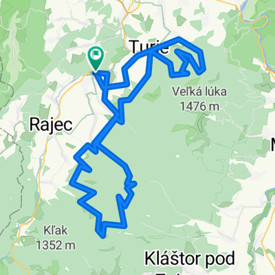
Kunerad - Krizava - Ostra - Kunerad
A cycling route starting in Rajec, Žilina Region, Slovakia.
Overview
About this route
- -:--
- Duration
- 31.9 km
- Distance
- 1,207 m
- Ascent
- 1,209 m
- Descent
- ---
- Avg. speed
- ---
- Max. altitude

Route photos


Route quality
Waytypes & surfaces along the route
Waytypes
Path
14.3 km
(45 %)
Track
13.7 km
(43 %)
Surfaces
Paved
6.1 km
(19 %)
Unpaved
13.8 km
(43 %)
Ground
7.9 km
(25 %)
Asphalt
3.7 km
(12 %)
Route highlights
Points of interest along the route
Point of interest after 6.3 km
HORNA LUKA
Point of interest after 8.8 km
VETERNE
Point of interest after 9.7 km
VIDLICA
Point of interest after 10.3 km
VELKA LUKA
Point of interest after 11.1 km
KRIZAVA
Point of interest after 13.4 km
SKALKA
Point of interest after 16.6 km
OSTRA - DOPRAVA ALEBO ROVNO
Continue with Bikemap
Use, edit, or download this cycling route
You would like to ride Kunerad - Krizava - Ostra - Kunerad or customize it for your own trip? Here is what you can do with this Bikemap route:
Free features
- Save this route as favorite or in collections
- Copy & plan your own version of this route
- Sync your route with Garmin or Wahoo
Premium features
Free trial for 3 days, or one-time payment. More about Bikemap Premium.
- Navigate this route on iOS & Android
- Export a GPX / KML file of this route
- Create your custom printout (try it for free)
- Download this route for offline navigation
Discover more Premium features.
Get Bikemap PremiumFrom our community
Other popular routes starting in Rajec
 Lapierre fatranský maratón 2012
- Distance
- 90 km
- Ascent
- 2,084 m
- Descent
- 2,093 m
- Location
- Rajec, Žilina Region, Slovakia
 Rajecké Teplice - Zámok Kunerád
- Distance
- 7.4 km
- Ascent
- 205 m
- Descent
- 6 m
- Location
- Rajec, Žilina Region, Slovakia
 Intersport Fatranský maratón 2012
- Distance
- 58.1 km
- Ascent
- 1,319 m
- Descent
- 1,328 m
- Location
- Rajec, Žilina Region, Slovakia
 10. Flámm- Krátky okruh Rajecké Teplice
- Distance
- 7.2 km
- Ascent
- 124 m
- Descent
- 124 m
- Location
- Rajec, Žilina Region, Slovakia
 Kvakobov trail 4
- Distance
- 27.3 km
- Ascent
- 825 m
- Descent
- 828 m
- Location
- Rajec, Žilina Region, Slovakia
 14.5.2016
- Distance
- 11.7 km
- Ascent
- 453 m
- Descent
- 456 m
- Location
- Rajec, Žilina Region, Slovakia
 3. Flámm- Okruh cez Turie
- Distance
- 18.9 km
- Ascent
- 670 m
- Descent
- 675 m
- Location
- Rajec, Žilina Region, Slovakia
 2. Flámm- Okruh cez Porubsku dolinu
- Distance
- 28.5 km
- Ascent
- 310 m
- Descent
- 309 m
- Location
- Rajec, Žilina Region, Slovakia
Open it in the app