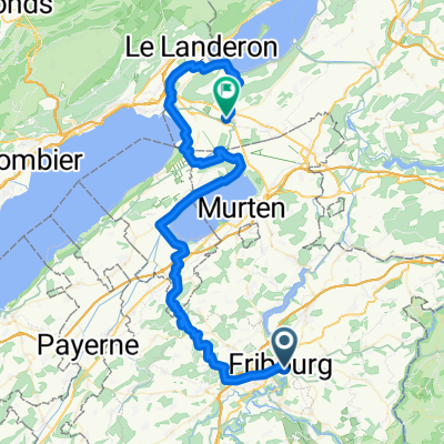
FR- Montagny Les Monts
A cycling route starting in Fribourg, Canton of Fribourg, Switzerland.
Overview
About this route
Old tower with dragon in Montagny. Stairs from km 7 to 7.5
- -:--
- Duration
- 32 km
- Distance
- 618 m
- Ascent
- 622 m
- Descent
- ---
- Avg. speed
- 729 m
- Max. altitude
Route quality
Waytypes & surfaces along the route
Waytypes
Track
13.4 km
(42 %)
Quiet road
11.8 km
(37 %)
Surfaces
Paved
9.6 km
(30 %)
Unpaved
13.1 km
(41 %)
Asphalt
9.6 km
(30 %)
Ground
9 km
(28 %)
Continue with Bikemap
Use, edit, or download this cycling route
You would like to ride FR- Montagny Les Monts or customize it for your own trip? Here is what you can do with this Bikemap route:
Free features
- Save this route as favorite or in collections
- Copy & plan your own version of this route
- Sync your route with Garmin or Wahoo
Premium features
Free trial for 3 days, or one-time payment. More about Bikemap Premium.
- Navigate this route on iOS & Android
- Export a GPX / KML file of this route
- Create your custom printout (try it for free)
- Download this route for offline navigation
Discover more Premium features.
Get Bikemap PremiumFrom our community
Other popular routes starting in Fribourg
- Fribourg - Lac Noir - Jaun - Ecuvillens - Fribourg
- Distance
- 88.9 km
- Ascent
- 1,322 m
- Descent
- 1,325 m
- Location
- Fribourg, Canton of Fribourg, Switzerland
- FR-Guglera 57
- Distance
- 56.7 km
- Ascent
- 925 m
- Descent
- 927 m
- Location
- Fribourg, Canton of Fribourg, Switzerland
- FR-Grandfey-Gottéron-Marly
- Distance
- 22.1 km
- Ascent
- 447 m
- Descent
- 452 m
- Location
- Fribourg, Canton of Fribourg, Switzerland
- Fribourg-Zofingen
- Distance
- 135.3 km
- Ascent
- 177 m
- Descent
- 384 m
- Location
- Fribourg, Canton of Fribourg, Switzerland
- Région Glâne- Sarine via Noréaz, Lovens, Posat
- Distance
- 37.6 km
- Ascent
- 472 m
- Descent
- 479 m
- Location
- Fribourg, Canton of Fribourg, Switzerland
- forests and brooks
- Distance
- 61.3 km
- Ascent
- 744 m
- Descent
- 743 m
- Location
- Fribourg, Canton of Fribourg, Switzerland
- Fribourg - Mont Gibloux
- Distance
- 48.7 km
- Ascent
- 1,146 m
- Descent
- 1,146 m
- Location
- Fribourg, Canton of Fribourg, Switzerland
- FR-Guglera 43
- Distance
- 42.6 km
- Ascent
- 785 m
- Descent
- 782 m
- Location
- Fribourg, Canton of Fribourg, Switzerland
Open it in the app