

Fairborn, Yellow Springs, Xenia, Beavercreek Loop
A cycling route starting in Wright-Patterson AFB, Ohio, United States of America.
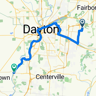
Overview
About this route
Mostly on bike paths, except between Fairborn and Yellow Springs
- -:--
- Duration
- 66.1 km
- Distance
- 167 m
- Ascent
- 167 m
- Descent
- ---
- Avg. speed
- ---
- Avg. speed
Route quality
Waytypes & surfaces along the route
Waytypes
Cycleway
28.5 km
(43 %)
Quiet road
12 km
(18 %)
Surfaces
Paved
14.7 km
(22 %)
Asphalt
9.4 km
(14 %)
Concrete
5.3 km
(8 %)
Undefined
51.4 km
(78 %)
Continue with Bikemap
Use, edit, or download this cycling route
You would like to ride Fairborn, Yellow Springs, Xenia, Beavercreek Loop or customize it for your own trip? Here is what you can do with this Bikemap route:
Free features
- Save this route as favorite or in collections
- Copy & plan your own version of this route
- Sync your route with Garmin or Wahoo
Premium features
Free trial for 3 days, or one-time payment. More about Bikemap Premium.
- Navigate this route on iOS & Android
- Export a GPX / KML file of this route
- Create your custom printout (try it for free)
- Download this route for offline navigation
Discover more Premium features.
Get Bikemap PremiumFrom our community
Other popular routes starting in Wright-Patterson AFB
 Sprint Triathlon Bike Route
- Distance
- 20 km
- Ascent
- 15 m
- Descent
- 19 m
- Location
- Wright-Patterson AFB, Ohio, United States of America
 Center Park @ Colonel Glenn, Fairborn to Elm Creek Circle 1101, Dayton
- Distance
- 39.6 km
- Ascent
- 1,175 m
- Descent
- 1,183 m
- Location
- Wright-Patterson AFB, Ohio, United States of America
 DAYTON RIDE -- Rayne & Papa
- Distance
- 23 km
- Ascent
- 49 m
- Descent
- 117 m
- Location
- Wright-Patterson AFB, Ohio, United States of America
 RAYNE2020
- Distance
- 44 km
- Ascent
- 68 m
- Descent
- 146 m
- Location
- Wright-Patterson AFB, Ohio, United States of America
 Triathlon 20K route
- Distance
- 9.9 km
- Ascent
- 36 m
- Descent
- 31 m
- Location
- Wright-Patterson AFB, Ohio, United States of America
 Huffman Dam - Dayton
- Distance
- 10.9 km
- Ascent
- 28 m
- Descent
- 52 m
- Location
- Wright-Patterson AFB, Ohio, United States of America
 panera route
- Distance
- 2.1 km
- Ascent
- 14 m
- Descent
- 8 m
- Location
- Wright-Patterson AFB, Ohio, United States of America
 4421 Union Rd, Dayton to 4485 Union Rd, Dayton
- Distance
- 2.7 km
- Ascent
- 59 m
- Descent
- 50 m
- Location
- Wright-Patterson AFB, Ohio, United States of America
Open it in the app