

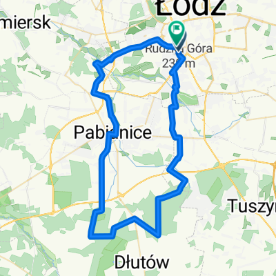
Łódź - Warszawa
A cycling route starting in Lodz, Łódź Voivodeship, Poland.
Overview
About this route
The route for road bikes. Mainly on national roads
- -:--
- Duration
- 140.6 km
- Distance
- 213 m
- Ascent
- 289 m
- Descent
- ---
- Avg. speed
- ---
- Max. altitude

Route quality
Waytypes & surfaces along the route
Waytypes
Road
52.6 km
(37 %)
Quiet road
35.8 km
(25 %)
Surfaces
Paved
120.7 km
(86 %)
Unpaved
2.1 km
(2 %)
Asphalt
115.7 km
(82 %)
Paving stones
4 km
(3 %)
Continue with Bikemap
Use, edit, or download this cycling route
You would like to ride Łódź - Warszawa or customize it for your own trip? Here is what you can do with this Bikemap route:
Free features
- Save this route as favorite or in collections
- Copy & plan your own version of this route
- Split it into stages to create a multi-day tour
- Sync your route with Garmin or Wahoo
Premium features
Free trial for 3 days, or one-time payment. More about Bikemap Premium.
- Navigate this route on iOS & Android
- Export a GPX / KML file of this route
- Create your custom printout (try it for free)
- Download this route for offline navigation
Discover more Premium features.
Get Bikemap PremiumFrom our community
Other popular routes starting in Lodz
 Na południe
- Distance
- 48 km
- Ascent
- 76 m
- Descent
- 72 m
- Location
- Lodz, Łódź Voivodeship, Poland
 EL >> EPA
- Distance
- 55 km
- Ascent
- 93 m
- Descent
- 93 m
- Location
- Lodz, Łódź Voivodeship, Poland
 Route to Zgierz
- Distance
- 12.5 km
- Ascent
- 60 m
- Descent
- 87 m
- Location
- Lodz, Łódź Voivodeship, Poland
 trzydziecha
- Distance
- 30.1 km
- Ascent
- 215 m
- Descent
- 218 m
- Location
- Lodz, Łódź Voivodeship, Poland
 Czarny szlak po PKWL (zredukowany)
- Distance
- 36.7 km
- Ascent
- 221 m
- Descent
- 221 m
- Location
- Lodz, Łódź Voivodeship, Poland
 Glowno
- Distance
- 67.8 km
- Ascent
- 215 m
- Descent
- 215 m
- Location
- Lodz, Łódź Voivodeship, Poland
 Kaszek_v3
- Distance
- 45.5 km
- Ascent
- 179 m
- Descent
- 177 m
- Location
- Lodz, Łódź Voivodeship, Poland
 Las Dąbrowa
- Distance
- 56.8 km
- Ascent
- 141 m
- Descent
- 151 m
- Location
- Lodz, Łódź Voivodeship, Poland
Open it in the app