

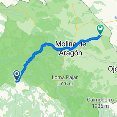
Villanueva - La Yunta
A cycling route starting in Villanueva de Alcorón, Castille-La Mancha, Spain.
Overview
About this route
- -:--
- Duration
- 70.9 km
- Distance
- 651 m
- Ascent
- 817 m
- Descent
- ---
- Avg. speed
- ---
- Max. altitude

Route quality
Waytypes & surfaces along the route
Waytypes
Busy road
34.4 km
(49 %)
Road
21 km
(30 %)
Surfaces
Paved
22.2 km
(31 %)
Unpaved
13.2 km
(19 %)
Asphalt
19.1 km
(27 %)
Ground
8.9 km
(13 %)
Continue with Bikemap
Use, edit, or download this cycling route
You would like to ride Villanueva - La Yunta or customize it for your own trip? Here is what you can do with this Bikemap route:
Free features
- Save this route as favorite or in collections
- Copy & plan your own version of this route
- Sync your route with Garmin or Wahoo
Premium features
Free trial for 3 days, or one-time payment. More about Bikemap Premium.
- Navigate this route on iOS & Android
- Export a GPX / KML file of this route
- Create your custom printout (try it for free)
- Download this route for offline navigation
Discover more Premium features.
Get Bikemap PremiumFrom our community
Other popular routes starting in Villanueva de Alcorón
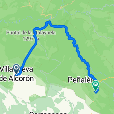 5. Villanueva de Alcoron-Ruta de los Maderos - Peñalen
- Distance
- 47 km
- Ascent
- 551 m
- Descent
- 632 m
- Location
- Villanueva de Alcorón, Castille-La Mancha, Spain
 Villanueva - La Yunta
- Distance
- 70.9 km
- Ascent
- 651 m
- Descent
- 817 m
- Location
- Villanueva de Alcorón, Castille-La Mancha, Spain
 Guadalajara - pista Tajo a checa y vuelta por Peralejos
- Distance
- 121 km
- Ascent
- 3,298 m
- Descent
- 3,298 m
- Location
- Villanueva de Alcorón, Castille-La Mancha, Spain
 Mongtañas vacias 04 Villanueva de Alcorcon - Beamud
- Distance
- 94.3 km
- Ascent
- 1,114 m
- Descent
- 1,051 m
- Location
- Villanueva de Alcorón, Castille-La Mancha, Spain
Open it in the app