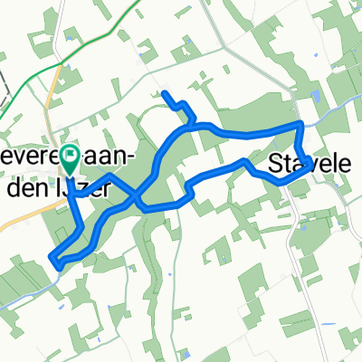
20160622_094445.gpx
A cycling route starting in Alveringem, Flemish Region, Belgium.
Overview
About this route
TEASI track
- -:--
- Duration
- 32.7 km
- Distance
- 5 m
- Ascent
- 10 m
- Descent
- ---
- Avg. speed
- ---
- Max. altitude
Route quality
Waytypes & surfaces along the route
Waytypes
Quiet road
19.6 km
(60 %)
Road
5.9 km
(18 %)
Surfaces
Paved
28.1 km
(86 %)
Unpaved
1 km
(3 %)
Asphalt
28.1 km
(86 %)
Ground
1 km
(3 %)
Undefined
3.6 km
(11 %)
Route highlights
Points of interest along the route
Point of interest after 11.8 km
7 Chemin des Moères
Point of interest after 12.8 km
8 Chemin des Moères
Point of interest after 24.1 km
51.012° 02.482°
Point of interest after 24.4 km
140 Rue des Pêcheurs
Continue with Bikemap
Use, edit, or download this cycling route
You would like to ride 20160622_094445.gpx or customize it for your own trip? Here is what you can do with this Bikemap route:
Free features
- Save this route as favorite or in collections
- Copy & plan your own version of this route
- Sync your route with Garmin or Wahoo
Premium features
Free trial for 3 days, or one-time payment. More about Bikemap Premium.
- Navigate this route on iOS & Android
- Export a GPX / KML file of this route
- Create your custom printout (try it for free)
- Download this route for offline navigation
Discover more Premium features.
Get Bikemap PremiumFrom our community
Other popular routes starting in Alveringem
- 20160622_Heen.gpx
- Distance
- 30.4 km
- Ascent
- 8 m
- Descent
- 14 m
- Location
- Alveringem, Flemish Region, Belgium
- polinkhove - 43.2
- Distance
- 43.2 km
- Ascent
- 72 m
- Descent
- 72 m
- Location
- Alveringem, Flemish Region, Belgium
- Beveren-Zuytcoote.gpx
- Distance
- 32.1 km
- Ascent
- 8 m
- Descent
- 14 m
- Location
- Alveringem, Flemish Region, Belgium
- 20160622_094445.gpx
- Distance
- 32.7 km
- Ascent
- 5 m
- Descent
- 10 m
- Location
- Alveringem, Flemish Region, Belgium
- Schrevepromenade 2025 - de 25km
- Distance
- 30.2 km
- Ascent
- 50 m
- Descent
- 51 m
- Location
- Alveringem, Flemish Region, Belgium
- Roesbruggestraat 19, Alveringem naar Roesbruggestraat 19, Alveringem
- Distance
- 8.5 km
- Ascent
- 8 m
- Descent
- 10 m
- Location
- Alveringem, Flemish Region, Belgium
- Avondrit: Oost-Cappel - Rexpoëde - Killem - Hondschoote - Houtem
- Distance
- 27.3 km
- Ascent
- 54 m
- Descent
- 63 m
- Location
- Alveringem, Flemish Region, Belgium
- pollinkhove-brakel.parike bivak-112km
- Distance
- 111.7 km
- Ascent
- 456 m
- Descent
- 390 m
- Location
- Alveringem, Flemish Region, Belgium
Open it in the app