
Green and Blue MTB Bike Tour
A cycling route starting in Lovran, Istarska Županija, Croatia.
Overview
About this route
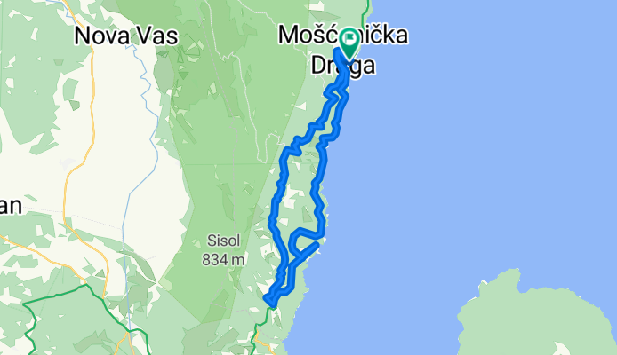
Mošćenička Draga - Brseč - Zagore - Sv. Jelena - Mošćenice - Mošćenička Draga
- -:--
- Duration
- 26.3 km
- Distance
- 590 m
- Ascent
- 590 m
- Descent
- ---
- Avg. speed
- ---
- Avg. speed

Route quality
Waytypes & surfaces along the route
Waytypes
Busy road
12.4 km
(47 %)
Track
4.9 km
(19 %)
Surfaces
Paved
11.8 km
(45 %)
Unpaved
5.7 km
(22 %)
Asphalt
11.8 km
(45 %)
Gravel
3.4 km
(13 %)
Continue with Bikemap
Use, edit, or download this cycling route
You would like to ride Green and Blue MTB Bike Tour or customize it for your own trip? Here is what you can do with this Bikemap route:
Free features
- Save this route as favorite or in collections
- Copy & plan your own version of this route
- Sync your route with Garmin or Wahoo
Premium features
Free trial for 3 days, or one-time payment. More about Bikemap Premium.
- Navigate this route on iOS & Android
- Export a GPX / KML file of this route
- Create your custom printout (try it for free)
- Download this route for offline navigation
Discover more Premium features.
Get Bikemap PremiumFrom our community
Other popular routes starting in Lovran
 Up to the top of Istria
- Distance
- 46.9 km
- Ascent
- 1,394 m
- Descent
- 1,394 m
- Location
- Lovran, Istarska Županija, Croatia
 52 Medveja-Sveti Anton-Sveti Petar-Trebišće-Mošćenice-Moščenička D.-Medveja
- Distance
- 22 km
- Ascent
- 814 m
- Descent
- 814 m
- Location
- Lovran, Istarska Županija, Croatia
 (GPS) Učka_Momčići_1
- Distance
- 7.7 km
- Ascent
- 374 m
- Descent
- 187 m
- Location
- Lovran, Istarska Županija, Croatia
 Ičići-Učka_06/2021
- Distance
- 23.4 km
- Ascent
- 1,406 m
- Descent
- 13 m
- Location
- Lovran, Istarska Županija, Croatia
 Istrien Bergtour
- Distance
- 49 km
- Ascent
- 1,658 m
- Descent
- 1,656 m
- Location
- Lovran, Istarska Županija, Croatia
 20. LK Brdo - Lisina -LK Brdo
- Distance
- 11.5 km
- Ascent
- 394 m
- Descent
- 349 m
- Location
- Lovran, Istarska Županija, Croatia
 MTB Učka ride - anticlockwise
- Distance
- 60.8 km
- Ascent
- 1,779 m
- Descent
- 1,777 m
- Location
- Lovran, Istarska Županija, Croatia
 tunel-korita
- Distance
- 39 km
- Ascent
- 851 m
- Descent
- 857 m
- Location
- Lovran, Istarska Županija, Croatia
Open it in the app