

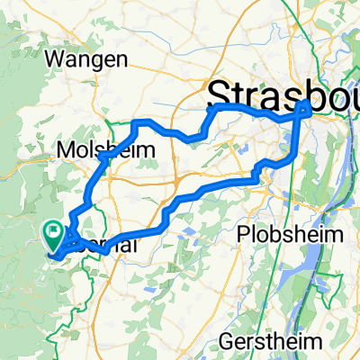
Route des vins I
A cycling route starting in Ottrott, Grand Est, France.
Overview
About this route
D109 přes Saint Nabor a Bernardswiller do Obernai;
D462 do Ottrott, D35 přes Boersch do Dorlisheim; D392 do Mutzig
D30 do Avolsheim; D422+D275 do Bergbieten;
D654+D75 do Westhoffen
- -:--
- Duration
- 39.4 km
- Distance
- 211 m
- Ascent
- 730 m
- Descent
- ---
- Avg. speed
- ---
- Max. altitude
Route quality
Waytypes & surfaces along the route
Waytypes
Busy road
16.9 km
(43 %)
Road
13.4 km
(34 %)
Surfaces
Paved
20 km
(51 %)
Asphalt
19.8 km
(50 %)
Paved (undefined)
0.2 km
(<1 %)
Continue with Bikemap
Use, edit, or download this cycling route
You would like to ride Route des vins I or customize it for your own trip? Here is what you can do with this Bikemap route:
Free features
- Save this route as favorite or in collections
- Copy & plan your own version of this route
- Sync your route with Garmin or Wahoo
Premium features
Free trial for 3 days, or one-time payment. More about Bikemap Premium.
- Navigate this route on iOS & Android
- Export a GPX / KML file of this route
- Create your custom printout (try it for free)
- Download this route for offline navigation
Discover more Premium features.
Get Bikemap PremiumFrom our community
Other popular routes starting in Ottrott
 Molsheim - Mont Sainte-Odile
- Distance
- 203.9 km
- Ascent
- 3,107 m
- Descent
- 3,675 m
- Location
- Ottrott, Grand Est, France
 Klingenthal(95km)
- Distance
- 105.6 km
- Ascent
- 2,957 m
- Descent
- 2,868 m
- Location
- Ottrott, Grand Est, France
 BTR 2017
- Distance
- 1,099.4 km
- Ascent
- 5,445 m
- Descent
- 5,562 m
- Location
- Ottrott, Grand Est, France
 Ottrott-Strasbourg-Ottrott
- Distance
- 89.9 km
- Ascent
- 435 m
- Descent
- 454 m
- Location
- Ottrott, Grand Est, France
 70km Klingenthal-Donon
- Distance
- 124.2 km
- Ascent
- 3,038 m
- Descent
- 3,071 m
- Location
- Ottrott, Grand Est, France
 ottrott 5 sept 10
- Distance
- 50 km
- Ascent
- 1,357 m
- Descent
- 1,348 m
- Location
- Ottrott, Grand Est, France
 Niedermünster Rosheim Mollkirch
- Distance
- 20.3 km
- Ascent
- 255 m
- Descent
- 459 m
- Location
- Ottrott, Grand Est, France
 Route des vins I
- Distance
- 39.4 km
- Ascent
- 211 m
- Descent
- 730 m
- Location
- Ottrott, Grand Est, France
Open it in the app