

Cucharon
A cycling route starting in Vera, Andalusia, Spain.
Overview
About this route
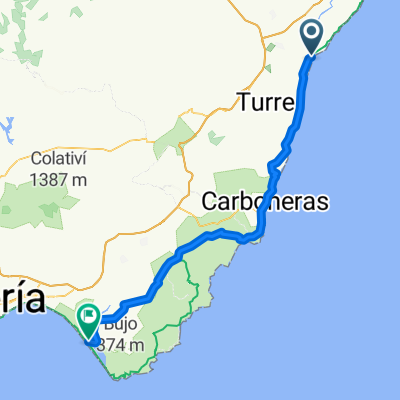
Starting from Vera, the route is fairly flat for the first 12km and then there is a climb of 8km to the top of the mountain. After the first 2km of the climb there are some interesting old mining buildings. At the top of the climb is an option to go to the aerial masts at the summit. From the top of the hill to the bar at Los Lobos is 24km almost entirely downhill.
- -:--
- Duration
- 44.7 km
- Distance
- 659 m
- Ascent
- 683 m
- Descent
- ---
- Avg. speed
- ---
- Max. altitude

Route highlights
Points of interest along the route
Point of interest after 4.2 km
Vera airfield
Point of interest after 12.1 km
Old silver mines
Point of interest after 14 km
View of the dam
Point of interest after 18.9 km
Aerial masts
Point of interest after 23.4 km
Enter the rambla here
Point of interest after 42.9 km
El Control bar at Los Lobos
Continue with Bikemap
Use, edit, or download this cycling route
You would like to ride Cucharon or customize it for your own trip? Here is what you can do with this Bikemap route:
Free features
- Save this route as favorite or in collections
- Copy & plan your own version of this route
- Sync your route with Garmin or Wahoo
Premium features
Free trial for 3 days, or one-time payment. More about Bikemap Premium.
- Navigate this route on iOS & Android
- Export a GPX / KML file of this route
- Create your custom printout (try it for free)
- Download this route for offline navigation
Discover more Premium features.
Get Bikemap PremiumFrom our community
Other popular routes starting in Vera
 VERA-Las Alparatas-TURRE-Cortijo Cabrera-La Carrasca-Los Moralicos-La Adelfa-SOPALMO-GARRUCHA-VERA
- Distance
- 67.3 km
- Ascent
- 1,196 m
- Descent
- 1,196 m
- Location
- Vera, Andalusia, Spain
 Ana-Isabel
- Distance
- 40.9 km
- Ascent
- 421 m
- Descent
- 444 m
- Location
- Vera, Andalusia, Spain
 I Desafío Baria Cross-Runing 2017
- Distance
- 23.1 km
- Ascent
- 229 m
- Descent
- 229 m
- Location
- Vera, Andalusia, Spain
 Vera Los Dioses
- Distance
- 51.9 km
- Ascent
- 963 m
- Descent
- 966 m
- Location
- Vera, Andalusia, Spain
 VERA-Las Cunas-PALOMARES-VILLARICOS-El Salar-VERA
- Distance
- 28.4 km
- Ascent
- 199 m
- Descent
- 199 m
- Location
- Vera, Andalusia, Spain
 Cucharon
- Distance
- 44.7 km
- Ascent
- 659 m
- Descent
- 683 m
- Location
- Vera, Andalusia, Spain
 Vera - Cabo de Gata 82km
- Distance
- 81.9 km
- Ascent
- 568 m
- Descent
- 563 m
- Location
- Vera, Andalusia, Spain
 Ovejuna
- Distance
- 45.3 km
- Ascent
- 429 m
- Descent
- 411 m
- Location
- Vera, Andalusia, Spain
Open it in the app