

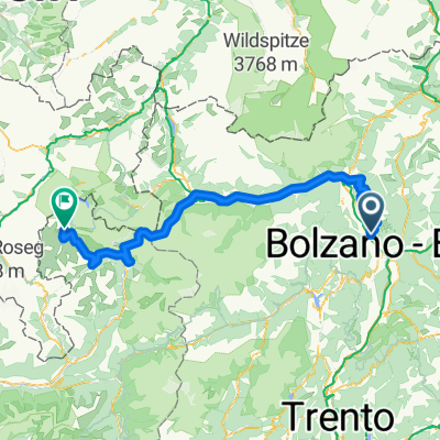
RBRower-dzien 7-04.08.16
A cycling route starting in Terlan, Trentino-Alto Adige, Italy.
Overview
About this route
- -:--
- Duration
- 130.2 km
- Distance
- 2,798 m
- Ascent
- 1,744 m
- Descent
- ---
- Avg. speed
- ---
- Max. altitude
Route quality
Waytypes & surfaces along the route
Waytypes
Busy road
65.8 km
(51 %)
Cycleway
24.2 km
(19 %)
Surfaces
Paved
124.2 km
(95 %)
Unpaved
3.4 km
(3 %)
Asphalt
124.1 km
(95 %)
Loose gravel
3.3 km
(3 %)
Continue with Bikemap
Use, edit, or download this cycling route
You would like to ride RBRower-dzien 7-04.08.16 or customize it for your own trip? Here is what you can do with this Bikemap route:
Free features
- Save this route as favorite or in collections
- Copy & plan your own version of this route
- Split it into stages to create a multi-day tour
- Sync your route with Garmin or Wahoo
Premium features
Free trial for 3 days, or one-time payment. More about Bikemap Premium.
- Navigate this route on iOS & Android
- Export a GPX / KML file of this route
- Create your custom printout (try it for free)
- Download this route for offline navigation
Discover more Premium features.
Get Bikemap PremiumFrom our community
Other popular routes starting in Terlan
 Sizilien Day3 Terlano - Riva del Garda
- Distance
- 113 km
- Ascent
- 575 m
- Descent
- 755 m
- Location
- Terlan, Trentino-Alto Adige, Italy
 Jaufen pass, Passo Pennes
- Distance
- 153.5 km
- Ascent
- 2,992 m
- Descent
- 2,992 m
- Location
- Terlan, Trentino-Alto Adige, Italy
 Terlan-Passo Stelvio-Livigno
- Distance
- 180 km
- Ascent
- 5,125 m
- Descent
- 3,407 m
- Location
- Terlan, Trentino-Alto Adige, Italy
 Terlan - Vilpian - Nals - Andrian
- Distance
- 13.4 km
- Ascent
- 107 m
- Descent
- 105 m
- Location
- Terlan, Trentino-Alto Adige, Italy
 Italien, Terlano nach Italien, Terlano
- Distance
- 59.4 km
- Ascent
- 599 m
- Descent
- 599 m
- Location
- Terlan, Trentino-Alto Adige, Italy
 Terlan - Meran
- Distance
- 21.2 km
- Ascent
- 63 m
- Descent
- 25 m
- Location
- Terlan, Trentino-Alto Adige, Italy
 Radtour durch Spargelfelder und blühende Apfelwiesen
- Distance
- 34.6 km
- Ascent
- 177 m
- Descent
- 179 m
- Location
- Terlan, Trentino-Alto Adige, Italy
 Stelvio pass, Umbrail pass
- Distance
- 200.9 km
- Ascent
- 2,508 m
- Descent
- 2,508 m
- Location
- Terlan, Trentino-Alto Adige, Italy
Open it in the app